IMAGES TAKEN NEAR TO
Kempestones Road, BELFAST, BT16 1UF
Introduction
This page details the photographs taken nearby to Kempestones Road, BT16 1UF by members of the Geograph project.
The Geograph project started in 2005 with the aim of publishing, organising and preserving representative images for every square kilometre of Great Britain, Ireland and the Isle of Man.

There are currently over 7.5m images from over14,400 individuals and you can help contribute to the project by visiting https://www.geograph.org.uk
Image Map
Images are licensed for reuse under creativecommons.org/licenses/by-sa/2.0
Notes
- Clicking on the map will re-center to the selected point.
- The higher the marker number, the further away the image location is from the centre of the postcode.
Image Listing (3 Images Found)
Images are licensed for reuse under creativecommons.org/licenses/by-sa/2.0
Image
Details
Distance
1
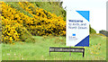
New Ards and North Down boundary sign near Dundonald (May 2015)
On 1 April 2015 local government was re-organised with most council areas (except Belfast) being amalgamated into larger districts. This sign, beside the dual carriageway, is at the boundary between the new Lisburn & Castlereagh and Ards & North Down districts – previously Castlereagh and Ards districts. It replaces one similar to this Image Before the formal boundary alterations “shadow” councils existed to plan the changeover.
Image: © Albert Bridge
Taken: 11 May 2015
0.13 miles
2
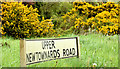
Name sign, Upper Newtownards Road, Dundonald (May 2015)
The Upper Newtownards Road starts at the Holywood Arches, Belfast Image and runs, via Dundonald village Image, to the eastern side of Dundonald Image where it becomes the Kempe Stones Road Image and http://www.megalithic.co.uk/article.php?sid=6333442.
Image: © Albert Bridge
Taken: 11 May 2015
0.15 miles
3
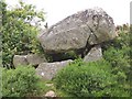
Kempe Stones Dolmen in a field boundary, Greengraves Road
Image: © Chris Burrell
Taken: 3 Jul 2008
0.25 miles