IMAGES TAKEN NEAR TO
Belfast Road, BELFAST, BT16 1UE
Introduction
This page details the photographs taken nearby to Belfast Road, BT16 1UE by members of the Geograph project.
The Geograph project started in 2005 with the aim of publishing, organising and preserving representative images for every square kilometre of Great Britain, Ireland and the Isle of Man.

There are currently over 7.5m images from over14,400 individuals and you can help contribute to the project by visiting https://www.geograph.org.uk
Image Map
Images are licensed for reuse under creativecommons.org/licenses/by-sa/2.0
Notes
- Clicking on the map will re-center to the selected point.
- The higher the marker number, the further away the image location is from the centre of the postcode.
Image Listing (11 Images Found)
Images are licensed for reuse under creativecommons.org/licenses/by-sa/2.0
Image
Details
Distance
1
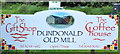
Dundonald Old Mill
Dundonald Old Mill entrance sign
Image: © RAY JONES
Taken: 18 Jun 2009
0.03 miles
2
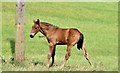
Foal, Dundonald (July 2015)
A foal visible from the Belfast Road Image
Image: © Albert Bridge
Taken: 17 Jul 2015
0.06 miles
3
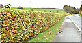
Beech hedge, Killarn, Dundonald (October 2017)
See Image The same hedge, now starting to show its autumn tint.
Image: © Albert Bridge
Taken: 24 Oct 2017
0.07 miles
4
Dundonald Old Mill
Dundonald Old Mill A lovely restored old mill.
Image: © RAY JONES
Taken: 18 Jun 2009
0.07 miles
5
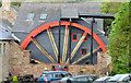
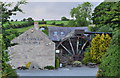
Waterwheel, Dundonald
The waterwheel http://www.dundonaldoldmill.co.uk/waterwheel.html which once powered the old mill Image – restored since this view Image in June 2009.
Image: © Albert Bridge
Taken: 9 Oct 2013
0.07 miles
6
The Old Mill, Dundonald
Now a coffee and gift shop http://www.dundonaldoldmill.co.uk/index.html the Old Mill was built circa 1752 as a bleachworks before being converted to a corn mill in the 19th century. For a more detailed history see http://www.doeni.gov.uk/niea/built/buildview?id=2543&js=true, http://www.doeni.gov.uk/niea/built/buildview?id=6604&js=true and
http://www.dundonaldoldmill.co.uk/buildings.html. Image shows the restored waterwheel.
Image: © Albert Bridge
Taken: 9 Oct 2013
0.09 miles
7
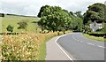
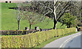
The Belfast Road, Dundonald (July 2015)
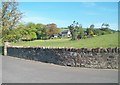
Before the opening of the dual carriageway Image in 1978 this was the main road from Belfast to Newtownards and much of the Ards Peninsula. It was then the A20 and merited green road signs. Now classified as the C264 Image and possibly the best-known “C” road in NI. For all I know it might even be the widest “C” road in the whole UK. Feel free to contact me with Geograph link to a wider one. The beech hedge (left) is a prominent feature in late autumn.
Image: © Albert Bridge
Taken: 17 Jul 2015
0.09 miles
8
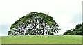
Trees, Dundonald (July 2015)
A line of trees, on the other side of a low drumlin, to the north west of the Belfast Road Image
Image: © Albert Bridge
Taken: 17 Jul 2015
0.10 miles
9
Beech hedge, Killarn, Dundonald (May 2017)
See Image Another beech hedge coming into leaf. This one is on the Belfast Road (left in Image). Continue to Image
Image: © Albert Bridge
Taken: 2 May 2017
0.15 miles