IMAGES TAKEN NEAR TO
Ballyregan Road, BELFAST, BT16 1TU
Introduction
This page details the photographs taken nearby to Ballyregan Road, BT16 1TU by members of the Geograph project.
The Geograph project started in 2005 with the aim of publishing, organising and preserving representative images for every square kilometre of Great Britain, Ireland and the Isle of Man.

There are currently over 7.5m images from over14,400 individuals and you can help contribute to the project by visiting https://www.geograph.org.uk
Image Map
Images are licensed for reuse under creativecommons.org/licenses/by-sa/2.0
Notes
- Clicking on the map will re-center to the selected point.
- The higher the marker number, the further away the image location is from the centre of the postcode.
Image Listing (4 Images Found)
Images are licensed for reuse under creativecommons.org/licenses/by-sa/2.0
Image
Details
Distance
1
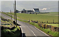
The Ballyregan Road near Dundonald (1)
A steep, narrow, twisting and unclassified road which drops some 450ft, in about 2½ miles, from the Ballymiscaw Road to the Upper Newtownards Road at Dundonald village. This view is towards Dundonald (hidden between the two hillsides) along a fairly typical stretch of the road. Image shows the view in the opposite direction. Image shows the road leaving Dundonald (November 2013).
Image: © Albert Bridge
Taken: 26 Mar 2012
0.12 miles
2
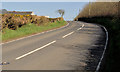
The Ballyregan Road near Dundonald (2)
See Image The view towards the Ballymiscaw Road.
Image: © Albert Bridge
Taken: 26 Mar 2012
0.24 miles
3
![Ballyregan Road near Dundonald [2]](https://s0.geograph.org.uk/photos/79/13/791352_396c0e5e_120x120.jpg)
Ballyregan Road near Dundonald [2]
Looking up the road in the opposite direction from Image
Image: © Rossographer
Taken: 6 May 2008
0.24 miles
4
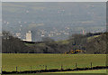
Fields near Dundonald (2)
See Image Slightly further down the road, looking more towards the south, the view becomes more urban/suburban. Dundonald and the eastern limit of Belfast are mainly hidden in the hollow. The block of flats is this one Image
Image: © Albert Bridge
Taken: 26 Mar 2012
0.25 miles