IMAGES TAKEN NEAR TO
Fountain Street, BELFAST, BT1 5EA
Introduction
This page details the photographs taken nearby to Fountain Street, BT1 5EA by members of the Geograph project.
The Geograph project started in 2005 with the aim of publishing, organising and preserving representative images for every square kilometre of Great Britain, Ireland and the Isle of Man.

There are currently over 7.5m images from over14,400 individuals and you can help contribute to the project by visiting https://www.geograph.org.uk
Image Map
Images are licensed for reuse under creativecommons.org/licenses/by-sa/2.0
Notes
- Clicking on the map will re-center to the selected point.
- The higher the marker number, the further away the image location is from the centre of the postcode.
Image Listing (3046 Images Found)
Images are licensed for reuse under creativecommons.org/licenses/by-sa/2.0
Image
Details
Distance
1
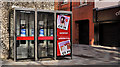
Telephone boxes, Belfast (11)
Three BT telephones boxes at the Castle Street end of Fountain Street.
Image: © Albert Bridge
Taken: 18 Mar 2012
0.01 miles
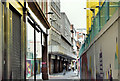
2
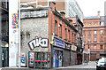
Nos 11-19 Fountain Street, Belfast
Two buildings between here Image (left) and Castle Street. The taller one (right) has been a bar for many years. No 19 (now a newsagent) was once occupied by one of the legends of Belfast past - the “Bonne Bouche” cafe.
Image: © Albert Bridge
Taken: 21 Jul 2013
0.01 miles
3
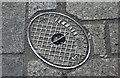
"Terrain" access cover, Belfast (February 2016)
An oval access cover, at Fountain Street, with the inscription “Terrain 4DRE”. No further information available.
Image: © Albert Bridge
Taken: 14 Feb 2016
0.01 miles
4
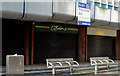
"To let" shop, Belfast (25)
A former branch of the “O’Brien’s” sandwich-shop franchise, on the ground floor of Norwich Union House Image, Fountain Street.
Image: © Albert Bridge
Taken: 4 Nov 2012
0.01 miles
5
Primark (Bank Buildings) fire, Belfast - March 2019(1)
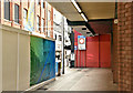
The covered walkway at Fountain Street. Norwich Union House is on the right. “A temporary walkway reconnecting Royal Avenue to Donegall Place is open and pedestrian access to Castle Street via Fountain Street has been restored. The footpath from the corner of Zara (on Donegall Place) to the corner of Fountain Street (City Picnic) is on schedule to be reopened at the end of March 2019” - Belfast City Council statement.
Image: © Albert Bridge
Taken: 7 Mar 2019
0.01 miles
6
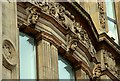
Former Anderson & McAuley's, Belfast (detail) (4)
Image: © Albert Bridge
Taken: 23 Mar 2008
0.01 miles
7
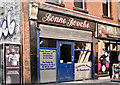
Former "Bonne Bouche", Belfast (September 2018)
The “Bonne Bouche” was a café and bakery trading from the 1930’s to the 1970’s, originally at no 7 and later no 19 Fountain Street. This exceptionally well-preserved hand-painted sign, previously hidden, is now on temporary view, during conversion work. The following planning permission (1 August 2018) applies “LA04/2018/0420/F Change of use of ground floor to café/bar preparing and serving hot food with late licence, new glazed shopfront and relocation of entrance to gable end. Internal reconfiguration of the first floor including installation of new staircase for access by patrons to the ground floor at number 19 and to act as a means of escape. 19 Fountain Street Belfast BT1 5EA”.
For something similar see Image
Image: © Albert Bridge
Taken: 24 Sep 2018
0.01 miles
8
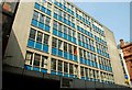
Norwich Union House, Belfast (2008)
A 60’s office building, on the corner of Fountain Street and Castle Street (right), there is a proposal to demolish and replace it with one of seven storeys.
Image: © Albert Bridge
Taken: 11 May 2008
0.01 miles
9
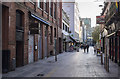
Fountain Street, Belfast
Fountain Street on a quiet Sunday morning. Not massively different from this view Image in May 2008, though the surfaces have been improved.
Image: © Rossographer
Taken: 6 Nov 2016
0.01 miles
10
Norwich Union House, Belfast - October 2019(1)
The view from the Donegall Place end of Castle Street. The Bank Buildings site is on the right.
Image: © Albert Bridge
Taken: 6 Oct 2019
0.01 miles