IMAGES TAKEN NEAR TO
Castle Arcade, BELFAST, BT1 5DF
Introduction
This page details the photographs taken nearby to Castle Arcade, BT1 5DF by members of the Geograph project.
The Geograph project started in 2005 with the aim of publishing, organising and preserving representative images for every square kilometre of Great Britain, Ireland and the Isle of Man.

There are currently over 7.5m images from over14,400 individuals and you can help contribute to the project by visiting https://www.geograph.org.uk
Image Map
Images are licensed for reuse under creativecommons.org/licenses/by-sa/2.0
Notes
- Clicking on the map will re-center to the selected point.
- The higher the marker number, the further away the image location is from the centre of the postcode.
Image Listing (3412 Images Found)
Images are licensed for reuse under creativecommons.org/licenses/by-sa/2.0
Image
Details
Distance
1
Former BHS (British Homes Stores), Castle Arcade, Belfast (August 2017)
The former British Home Stores on both sides of the Castle Arcade, vacant and neglected. A sad sight compared with the once-bright interior of a business renowned for design. The view is towards High Street.
Image: © Albert Bridge
Taken: 20 Aug 2017
0.01 miles
2
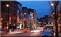
High Street, Belfast
The evening view along High Street, towards Castle Junction, with a few Christmas lights on display.
Image: © Albert Bridge
Taken: 29 Nov 2007
0.01 miles
3

Primark (Bank Buildings) fire, Belfast - August 2018(18)
Fire officers’ cars at Castle Place.
Image: © Albert Bridge
Taken: 30 Aug 2018
0.01 miles
4
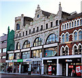
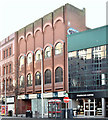
Castle Buildings, Castle Place, Belfast (2)
Castle Buildings was completed in 1905 and extended in 1907 to a design by Blackwood and Jury. The upper floors feature an art noveau frieze designed by Percy Jury. Image showed the roof-level detail (May 2007). For comparison see Image
Image: © Albert Bridge
Taken: 1 Jan 2012
0.01 miles
5
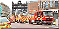
Primark (Bank Buildings) fire, Belfast - August 2018(8)
An ambulance and several Fire Brigade vehicles, about seven hours after the fire started, at Castle Place.
Image: © Albert Bridge
Taken: 28 Aug 2018
0.01 miles
6
Primark (Bank Buildings) fire, Belfast - December 2018(3)
The “Yellow Dot Trail” is a way of guiding people around around that part of the city centre closed following the Primark (Bank Buildings) fire. Yellow dots, on the footpaths, are supplemented by ones on lampposts and by street maps. This map is at Castle Place/Cornmarket/High Street.
Image: © Albert Bridge
Taken: 2 Dec 2018
0.01 miles
7
Mural, Belfast
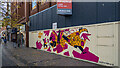
Artwork by David J. McMillan https://www.instagram.com/davidjmcmillan/ at Cornmarket, Belfast. Formerly BHS - see Image
Image: © Rossographer
Taken: 18 Oct 2020
0.01 miles
8

Street entertainment, Belfast
Pictured near Ann Street
Image: © Kenneth Allen
Taken: 13 May 2009
0.01 miles
9
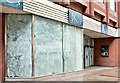
Former BHS (British Homes Stores), Belfast (August 2017)
The Cornmarket entrance to the former BHS (British Home Stores). Almost a year after closure the premises are still vacant.
Image: © Albert Bridge
Taken: 7 Aug 2017
0.01 miles
10
Former BHS (British Home Stores), Belfast - January 2018(2)
The Cornmarket side. My reading of the plans (available on the NI Planning Portal) suggests that only the ground floor will see any substantial change.
Image: © Albert Bridge
Taken: 7 Jan 2018
0.01 miles