IMAGES TAKEN NEAR TO
Chichester Gardens, BELFAST, BT15 5FS
Introduction
This page details the photographs taken nearby to Chichester Gardens, BT15 5FS by members of the Geograph project.
The Geograph project started in 2005 with the aim of publishing, organising and preserving representative images for every square kilometre of Great Britain, Ireland and the Isle of Man.

There are currently over 7.5m images from over14,400 individuals and you can help contribute to the project by visiting https://www.geograph.org.uk
Image Map
Images are licensed for reuse under creativecommons.org/licenses/by-sa/2.0
Notes
- Clicking on the map will re-center to the selected point.
- The higher the marker number, the further away the image location is from the centre of the postcode.
Image Listing (11 Images Found)
Images are licensed for reuse under creativecommons.org/licenses/by-sa/2.0
Image
Details
Distance
1
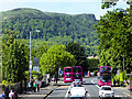
The Antrim Road and Napoleon's Nose
The Antrim Road is a major arterial route and area of housing and commerce that runs from inner city north Belfast to Dunadry. It forms part of the A6 road, a traffic route which links Belfast to Derry.
The hill in the background is Cave Hill (sometimes written as Cavehill), a basaltic hill which overlooks the city of Belfast. The hill is also referred to locally as Napoleon's Nose, as when seen in silhouette the summit is said to resemble a gigantic profile of the emperor Napoleon staring upwards (http://www.belfasttelegraph.co.uk/life/weekend/napoleon-nose-a-thing-or-two-about-cave-hill-28506267.html Belfast Telegraph). It is also sometimes said that Cave Hill was inspiration for Jonathan Swift's Gulliver's Travels. Swift imagined that the Cave Hill resembled the shape of a sleeping giant safeguarding the city.
Image: © David Dixon
Taken: 26 May 2017
0.07 miles
2

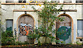
Bearnageeha ("Barney") mural, Belfast
Self-explanatory mural on a wall at St Patrick’s College, Bearnageeha (“Barney”) on the Antrim Road.
Image: © Albert Bridge
Taken: 20 Oct 2012
0.11 miles
3
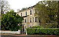
Nos 508-510 Antrim Road, Belfast (1)
A pair of very large semis, now vacant and semi derelict, close to the Old Cavehill Road, to which the following planning permission applies: “Z/2008/0119/F 10/01/2008 508-510 Antrim Road, Ballyaghagan, Belfast, BT15 5GG Demolition of existing building and erection of 9 No. apartments in a single block including carparking and landscaping” . . . “PERMISSION HAS BEEN GRANTED . . . 23/06/2008”.
No 508 (left) is roofless. This photograph appears as a matter of geographical and historical record only. I have no connection with any of the parties involved in the proposed development. See also Image
Note added 17 May 2013: now demolished.
Image: © Albert Bridge
Taken: 20 Oct 2012
0.13 miles
4
Nos 508-510 Antrim Road, Belfast (2)
See Image The front view. No 508 is on the left. This photograph appears as a matter of geographical and historical record only. I have no connection with any of the parties involved in the proposed development. Note added 17 May 2013: now demolished.
Image: © Albert Bridge
Taken: 20 Oct 2012
0.13 miles
5
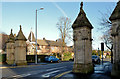
Fortwilliam Gates, Belfast - 2014 (1)
The elaborate, but not so ornate, gates at the Antrim Road end of Fortwilliam Park.
Image: © Albert Bridge
Taken: 6 Feb 2014
0.22 miles
6
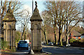
Fortwilliam Gates, Belfast - 2014 (2)
The two pillars on the northern side of Fortwilliam Park (Antrim Road end).
Image: © Albert Bridge
Taken: 6 Feb 2014
0.22 miles
7
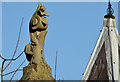
Fortwilliam Gates, Belfast - 2014 (3)
Detail from the pillar on the left in Image Part of the former gate lodge is on the right.
Image: © Albert Bridge
Taken: 6 Feb 2014
0.22 miles
8
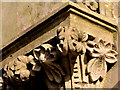
Fortwilliam Gates, Belfast - 2014 (4)
Detail from the pillar on the left in Image
Image: © Albert Bridge
Taken: 6 Feb 2014
0.22 miles
9
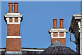
Chimneys and chimney pots, Fortwilliam, Belfast
Two chimneys, with six pots made with integral caps, on a late-Victorian former villa on the northern side of Fortwilliam Park.
Image: © Albert Bridge
Taken: 6 Feb 2014
0.23 miles
10
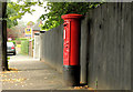
Pillar box, Belfast
EVIIR pillar box (BT15 188), at Fortwilliam Park, close to the corner of the Somerton Road. Last seen in July 2007 Image
Image: © Albert Bridge
Taken: 15 Aug 2012
0.23 miles