1
Whitewell Metropolitan Tabernacle, Belfast
Whitewell Metropolitan Tabernacle in Shore Road is an Elim Pentecostal church. Elim Pentecostal is a movement started by Pastor George Jeffreys (1889–1962), a Welshman, in Co. Monaghan, Ireland in 1915. The First Minister of Northern Ireland, Peter Robinson, is amongst the church's 2,600 members.
Image: © Eric Jones
Taken: 23 Sep 2013
0.04 miles
2
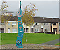
Shore Crescent, Belfast (2)
Despite the name the estate is laid out on strict right-angled geometric lines – in this case a square. The view, approximately north west, across the square. The feature (left) is inscribed “Sailortown”. When Sailortown http://www.geograph.org.uk/search.php?i=45062275 was flattened in the 1960/70’s to make way for the M2 some of its residents moved here.
Image: © Albert Bridge
Taken: 11 Nov 2013
0.07 miles
3
Development site, Fortwilliam, Belfast
A site, at 809-811 Shore Road, described by the agents as “A cleared corner site of c. 0.42 acres between the Shore Road and Strand Crescent; which previously sited a petrol filling station . . . . The site benefits from Full Planning granted in May 2009 for the development of 43no. two bed apartments, with a double basement car park below. The proposed scheme incorporates a ‘stepped’ high rise design, ranging from 7 to 4 storeys”. This photograph appears as a matter of record only. I have no connection with any of the parties involved in the sale.
Image: © Albert Bridge
Taken: 11 Nov 2013
0.07 miles
4
Old Trolley Bus
The last trolley bus to operate in Northern Ireland was #202 GZ8566, is travelling along the Shore Rd, towards Belfast passing an area of waste ground that later became Loughside Park
Image: © Wilson Adams
Taken: 11 May 1968
0.09 miles
5
"Sailortown" feature, Shore Crescent, Belfast
A feature, the square, inscribed “Sailortown”. When Sailortown http://www.geograph.org.uk/search.php?i=45062275 was flattened in the 1960/70’s to make way for the M2 some of its residents moved here.
Image: © Albert Bridge
Taken: 11 Nov 2013
0.09 miles
6
Shore Crescent, Belfast (1)
Despite the name the estate is laid out on strict right-angled geometric lines – in this case a square. The Horizon Building
Image is in the background, on the Shore Road. The boarded-up block on the right is a case where appearances can be deceptive. It’s relatively new but still unlet. The agents’ website shows it as completely modern inside.
Image: © Albert Bridge
Taken: 11 Nov 2013
0.10 miles
7
The Horizon Building, Belfast (1)
Five blocks of apartments, at 670-678 Shore Road, which rise progressively in height from south to north. This view is from the north east.
Image shows the view from the south east.
Image: © Albert Bridge
Taken: 11 Nov 2013
0.12 miles
8
The Horizon Building, Belfast (2)
See
Image The view from the south east.
Image: © Albert Bridge
Taken: 11 Nov 2013
0.12 miles
9
M2 Motorway at Junction 2
The M2 is the main road north from Belfast, carrying traffic from the city to the north and north-west of the province. Junction 2 is the interchange with the M5 which links to the A2 Antrim coastal route.
Image: © David Dixon
Taken: 29 Sep 2017
0.13 miles
10
Motorways merging near Belfast
The efficiency of the landscaping (seen in
Image) and the flat surroundings prevent a proper shot of the merger of the M2 and the M5. The three southbound lanes of the former are in the foreground. The two lanes of the M5, coming in from Rushpark, are between the grass and the crash barrier (middle). The motorway drops a lane approaching the Fortwilliam junction
Image off-slip and gains it again once past the on-slip. The lanes then continue as described in
Image
Image: © Albert Bridge
Taken: 10 May 2011
0.15 miles


