IMAGES TAKEN NEAR TO
Downview Gardens, BELFAST, BT15 4GH
Introduction
This page details the photographs taken nearby to Downview Gardens, BT15 4GH by members of the Geograph project.
The Geograph project started in 2005 with the aim of publishing, organising and preserving representative images for every square kilometre of Great Britain, Ireland and the Isle of Man.

There are currently over 7.5m images from over14,400 individuals and you can help contribute to the project by visiting https://www.geograph.org.uk
Image Map
Images are licensed for reuse under creativecommons.org/licenses/by-sa/2.0
Notes
- Clicking on the map will re-center to the selected point.
- The higher the marker number, the further away the image location is from the centre of the postcode.
Image Listing (16 Images Found)
Images are licensed for reuse under creativecommons.org/licenses/by-sa/2.0
Image
Details
Distance
1
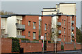
The Horizon Building, Belfast (2)
See Image The view from the south east.
Image: © Albert Bridge
Taken: 11 Nov 2013
0.14 miles
2
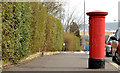
Pillar box BT15 706, Belfast
A GVIR pillar box (BT15 706) at Donegall Park Avenue, east of Castle Gardens.
Image: © Albert Bridge
Taken: 24 Mar 2014
0.14 miles
3
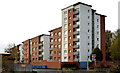
The Horizon Building, Belfast (1)
Five blocks of apartments, at 670-678 Shore Road, which rise progressively in height from south to north. This view is from the north east. Image shows the view from the south east.
Image: © Albert Bridge
Taken: 11 Nov 2013
0.14 miles
4

"Enviro-Grate", Belfast
An “Enviro-Grate” grating cover at the Donegall Park Avenue end of Castle Gardens – one of several in the street. Described by the makers, Pipeline and Drainage Systems Limited of Sheffield http://www.pds-plc.com/envirograte.aspx, as being made from a unique 100% composite recycled material that has no resale value and no danger of theft. This photograph appears as a matter of geographical and historical record only. It is not an advertisement. I have no connection with the manufacturer.
Image: © Albert Bridge
Taken: 24 Mar 2014
0.15 miles
5
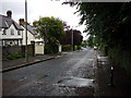
Downview Avenue, Belfast
Residential street off the Antrim Road in north Belfast.
Image: © Rossographer
Taken: 14 Jul 2010
0.16 miles
6
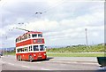
Old Trolley Bus
The last trolley bus to operate in Northern Ireland was #202 GZ8566, is travelling along the Shore Rd, towards Belfast passing an area of waste ground that later became Loughside Park
Image: © Wilson Adams
Taken: 11 May 1968
0.16 miles
7
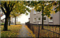
Autumn trees and leaves, Fortwilliam, Belfast
Autumn trees and leaves, along a footpath, close to the southern entrance to Shore Crescent.
Image: © Albert Bridge
Taken: 11 Nov 2013
0.17 miles
8
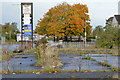
Development site, Fortwilliam, Belfast
A site, at 809-811 Shore Road, described by the agents as “A cleared corner site of c. 0.42 acres between the Shore Road and Strand Crescent; which previously sited a petrol filling station . . . . The site benefits from Full Planning granted in May 2009 for the development of 43no. two bed apartments, with a double basement car park below. The proposed scheme incorporates a ‘stepped’ high rise design, ranging from 7 to 4 storeys”. This photograph appears as a matter of record only. I have no connection with any of the parties involved in the sale.
Image: © Albert Bridge
Taken: 11 Nov 2013
0.18 miles
9
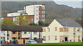
Shore Crescent, Belfast (1)
Despite the name the estate is laid out on strict right-angled geometric lines – in this case a square. The Horizon Building Image is in the background, on the Shore Road. The boarded-up block on the right is a case where appearances can be deceptive. It’s relatively new but still unlet. The agents’ website shows it as completely modern inside.
Image: © Albert Bridge
Taken: 11 Nov 2013
0.19 miles
10
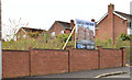
Donegall Park Mews, Belfast (March 2014)
A vacant site, on the southern side of Donegall Park Avenue, between Castle Gardens and Inisfayle Drive, with an agents’ board advertising a proposed development of seven houses. This photograph appears as a matter of geographical and historical record only. I have no connection with any of the parties involved in the proposed development and sale.
Image: © Albert Bridge
Taken: 24 Mar 2014
0.20 miles