IMAGES TAKEN NEAR TO
Cosgrave Court, BELFAST, BT15 2LU
Introduction
This page details the photographs taken nearby to Cosgrave Court, BT15 2LU by members of the Geograph project.
The Geograph project started in 2005 with the aim of publishing, organising and preserving representative images for every square kilometre of Great Britain, Ireland and the Isle of Man.

There are currently over 7.5m images from over14,400 individuals and you can help contribute to the project by visiting https://www.geograph.org.uk
Image Map
Images are licensed for reuse under creativecommons.org/licenses/by-sa/2.0
Notes
- Clicking on the map will re-center to the selected point.
- The higher the marker number, the further away the image location is from the centre of the postcode.
Image Listing (37 Images Found)
Images are licensed for reuse under creativecommons.org/licenses/by-sa/2.0
Image
Details
Distance
1
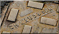
"GH Laud" manhole cover, Belfast (2)
See Image The maker’s name.
Image: © Albert Bridge
Taken: 4 Mar 2014
0.07 miles
2
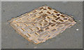
"GH Laud" manhole cover, Belfast (1)
See Image A GH Laud manhole cover at Robina Street, off the Limestone Road – very rare in NI. Image shows the maker’s name.
Image: © Albert Bridge
Taken: 4 Mar 2014
0.07 miles
3
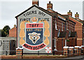
Tiger's Bay First Flute Band mural, Belfast (February 2016)
See Image (November 2011). A Tiger’s Bay First Flute Band mural at Hogarth Street/Mervue Street. This photograph appears as a matter of neutral record only. It should not be interpreted as making any political, sectarian or musical comment. See also Image and Image
Image: © Albert Bridge
Taken: 24 Feb 2016
0.08 miles
4
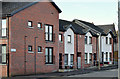
Glenrosa Street, Belfast (February 2016)
The original Glenrosa Street, built before 1890, was much longer and ran from Mervue Street through to Duncairn Gardens. This is the re-built version seen from Mervue Street.
Image: © Albert Bridge
Taken: 24 Feb 2016
0.12 miles
5
Lilliput Street, Belfast (February 2016)
Modern social housing in Lilliput Street, now a short street on the western side of North Queen Street. The original (much longer) street was built before 1880 and might take its name from a Lilliput Cottage on the nearby Limestone Road Image
Image: © Albert Bridge
Taken: 24 Feb 2016
0.14 miles
6
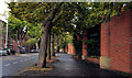
Duncairn Gardens, Belfast
A late 19th century street, running from North Queen Street (behind me) to the Antrim Road (Duncairn Street at the time of building). This tree-lined section is just past Edlingham Street. Much of the lower end has been redeveloped for commercial use.
Image: © Albert Bridge
Taken: 8 Sep 2011
0.14 miles
7
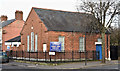
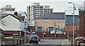
Belfast City Mission (Mountcollyer Hall), Belfast (February 2016)
Belfast City Mission http://www.belfastcitymission.com/, Mountcollyer Hall, at the corner of Mountcollyer Avenue (left) and North Queen Street. It seems to be of relatively-recent construction – possibly after 1960.
Image: © Albert Bridge
Taken: 24 Feb 2016
0.14 miles
8
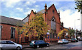
Former Macrory Memorial Presbyterian church, Belfast
The former Macrory Memorial Presbyterian church, in Duncairn Gardens, opposite Edlingham Street. It seems to date from 1896 when it replaced one in Gt George’s Street. Currently vacant and with a “to let” sign. My understanding is that an application for planning permission Z/2008/1584/F Construction of a 3-storey building comprising 12no. 2 bedroom apartments with access from both Duncairn Gardens & Hillman Street [amended scheme]” was not approved. Not listed and not on the “at risk” register.
Note added 25 November 2011 - there is an application for planning permission, listed under the streamlined procedure, as follows: “Z/2011/1280/F Macrory Memorial Presbyterian Church Duncairn Gardens Belfast BT15 2GN Change of use from church building to 2no hot food takeaways with alterations to front elevation”.
Image: © Albert Bridge
Taken: 8 Sep 2011
0.15 miles
9

Tiger's Bay mural, Belfast
Self-explanatory mural at the corner of North Queen Street and the Limestone Road Image Tiger’s Bay is an area of inner-city north Belfast, between Brougham Street Image, North Queen Street and the Limestone and York Roads, which experienced considerable upheaval during the Troubles.
Image: © Albert Bridge
Taken: 21 Nov 2011
0.16 miles
10
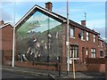
Belfast: an apolitical mural
While many of the murals around Belfast remind us of the city's political troubles of the 20th century, this one depicts the 'great hunger', as written in English under the right-hand part of the gable. The left-hand part says the same in Gaelic.
Image: © Chris Downer
Taken: 11 Nov 2007
0.16 miles