IMAGES TAKEN NEAR TO
Lepper Street, BELFAST, BT15 2FH
Introduction
This page details the photographs taken nearby to Lepper Street, BT15 2FH by members of the Geograph project.
The Geograph project started in 2005 with the aim of publishing, organising and preserving representative images for every square kilometre of Great Britain, Ireland and the Isle of Man.

There are currently over 7.5m images from over14,400 individuals and you can help contribute to the project by visiting https://www.geograph.org.uk
Image Map
Images are licensed for reuse under creativecommons.org/licenses/by-sa/2.0
Notes
- Clicking on the map will re-center to the selected point.
- The higher the marker number, the further away the image location is from the centre of the postcode.
Image Listing (31 Images Found)
Images are licensed for reuse under creativecommons.org/licenses/by-sa/2.0
Image
Details
Distance
1
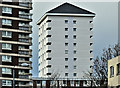
Renovated block, Artillery Flats, Belfast (January 2017)
See Image A second renovated block – at the north western end of the site.
Image: © Albert Bridge
Taken: 3 Jan 2017
0.09 miles
2
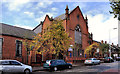
Former Macrory Memorial Presbyterian church, Belfast
The former Macrory Memorial Presbyterian church, in Duncairn Gardens, opposite Edlingham Street. It seems to date from 1896 when it replaced one in Gt George’s Street. Currently vacant and with a “to let” sign. My understanding is that an application for planning permission Z/2008/1584/F Construction of a 3-storey building comprising 12no. 2 bedroom apartments with access from both Duncairn Gardens & Hillman Street [amended scheme]” was not approved. Not listed and not on the “at risk” register.
Note added 25 November 2011 - there is an application for planning permission, listed under the streamlined procedure, as follows: “Z/2011/1280/F Macrory Memorial Presbyterian Church Duncairn Gardens Belfast BT15 2GN Change of use from church building to 2no hot food takeaways with alterations to front elevation”.
Image: © Albert Bridge
Taken: 8 Sep 2011
0.09 miles
3
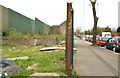
Vacant site, Duncairn Gardens, Belfast
A vacant site, on the south western side of Duncairn Gardens, close to the original line of Upper Meadow Street.
Image: © Albert Bridge
Taken: 10 Apr 2014
0.10 miles
4
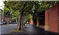
Duncairn Gardens, Belfast
A late 19th century street, running from North Queen Street (behind me) to the Antrim Road (Duncairn Street at the time of building). This tree-lined section is just past Edlingham Street. Much of the lower end has been redeveloped for commercial use.
Image: © Albert Bridge
Taken: 8 Sep 2011
0.12 miles
5

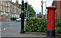
Victorian pillar box, Belfast
A VR pillar box, cast by A Handyside & Co Ltd http://www.geograph.org.uk/search.php?i=24683182, near the North Queen Street end of Duncairn Gardens Image
Image: © Albert Bridge
Taken: 8 Sep 2011
0.12 miles
6
Pillar box, Belfast
GVIR pillar box, on the Antrim Road just past Dawson Street.
Image: © Albert Bridge
Taken: 23 May 2011
0.15 miles
7
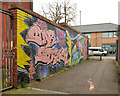
Graffiti, Belfast (April 2014)
“Still star struck after 2 years” on a gated entry leading from Hillman Court to Duncairn Gardens.
Image: © Albert Bridge
Taken: 10 Apr 2014
0.15 miles
8
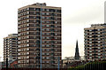
Artillery flats, Belfast
The view from Brougham Street Image
Image: © Albert Bridge
Taken: 5 Feb 2010
0.16 miles
10
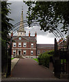
Clifton House
Entrance gates to Clifton House
One of Belfast’s most historic buildings, Clifton House was completed in 1774 by the Belfast Charitable Society as a base for their work with the poor and needy. It is usually open for tours during the European Heritage Open Days in September each year and is well worth a visit. http://www.cliftonbelfast.org.uk/home.htm
Image: © Rossographer
Taken: 30 Jul 2007
0.17 miles