IMAGES TAKEN NEAR TO
Thomas Street, BELFAST, BT15 1FF
Introduction
This page details the photographs taken nearby to Thomas Street, BT15 1FF by members of the Geograph project.
The Geograph project started in 2005 with the aim of publishing, organising and preserving representative images for every square kilometre of Great Britain, Ireland and the Isle of Man.

There are currently over 7.5m images from over14,400 individuals and you can help contribute to the project by visiting https://www.geograph.org.uk
Image Map
Images are licensed for reuse under creativecommons.org/licenses/by-sa/2.0
Notes
- Clicking on the map will re-center to the selected point.
- The higher the marker number, the further away the image location is from the centre of the postcode.
Image Listing (1235 Images Found)
Images are licensed for reuse under creativecommons.org/licenses/by-sa/2.0
Image
Details
Distance
1
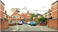
Thomas Street, Belfast
Built around 1850, Thomas Street ran from Gt George’s Street to Lancaster Street Image (background). Today’s version still does. Its eastern neighbour, Portland Street, no longer exists.
Image: © Albert Bridge
Taken: 23 Jul 2009
0.02 miles
2
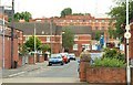
Lancaster Street, Belfast
Lancaster Street originally ran from York Street (behind me) to North Queen Street. Re-built in the 1980’s there is no direct access to North Queen Street. The original street was the birthplace of the boxer Rinty Monaghan Image
Image: © Albert Bridge
Taken: 12 Jul 2009
0.02 miles
3
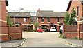
Portland Place, Belfast
Modern houses, built in the courtyard style, off Gt George’s Street Image Don’t, however, expect to find Scudder, Richard Hannay or the Black Stone.
Image: © Albert Bridge
Taken: 26 Jul 2009
0.02 miles
4
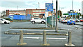
Car park, York Street, Belfast (November 2018)
A pay and display car park bounded by Lancaster Street (hidden, left), Gt George’s Street and York Street (right). 53 spaces but none dedicated for use by the disabled. Close to but outside the area reserved for the proposed Westlink/M2/M3 flyovers.
Image: © Albert Bridge
Taken: 10 Nov 2018
0.03 miles
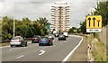
5
The Westlink/York Street, Belfast (2 in 2013)
The south/west-bound Westlink on-slip seen from York Street.
Image: © Albert Bridge
Taken: 10 Dec 2013
0.04 miles
6

Great Gerorge's Street, Belfast
Heading north-west
Image: © Kenneth Allen
Taken: 14 May 2019
0.04 miles
7
Great George's Street, Belfast
Gt George’s Street runs from Corporation Street, across York Street, to North Queen Street. Until the clearances for the M2 and Westlink it was a mixed commercial and residential street. This is the section from York Street to North Queen Street. The southern side (left) has been rebuilt with modern houses. The northern side is now the Westlink Image Continue to Image
Image: © Albert Bridge
Taken: 26 Jul 2009
0.05 miles
8
Translink "Enterprise" poster, Belfast - March 2014(2)
See Image The second in the series. This one is at the Westlink on-slip, York Street.
Image: © Albert Bridge
Taken: 21 Mar 2014
0.05 miles
9

Ifex 2018 poster, Belfast (March 2018)
A poster, at York Street/the Westlink, advertising a trade exhibition for the hospitality business - a sector which, currently, seems to be expanding. I have no connection with the event.
Image: © Albert Bridge
Taken: 8 Mar 2018
0.05 miles
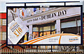
10
The Westlink, York Street, Belfast
See Image and Image The start of the Westlink, at York Street for traffic heading towards the M1. There are (resurrected) plans for a major elevated interchange here to connect the road to the M2 and M3. The route confirmatory sign (middle) shows the distance to Dublin as 104 miles.
Image: © Albert Bridge
Taken: 26 Jul 2009
0.05 miles