IMAGES TAKEN NEAR TO
York Street, BELFAST, BT15 1AT
Introduction
This page details the photographs taken nearby to York Street, BT15 1AT by members of the Geograph project.
The Geograph project started in 2005 with the aim of publishing, organising and preserving representative images for every square kilometre of Great Britain, Ireland and the Isle of Man.

There are currently over 7.5m images from over14,400 individuals and you can help contribute to the project by visiting https://www.geograph.org.uk
Image Map
Images are licensed for reuse under creativecommons.org/licenses/by-sa/2.0
Notes
- Clicking on the map will re-center to the selected point.
- The higher the marker number, the further away the image location is from the centre of the postcode.
Image Listing (1521 Images Found)
Images are licensed for reuse under creativecommons.org/licenses/by-sa/2.0
Image
Details
Distance
1

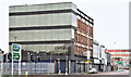
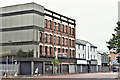
Nos 48-52 York Street, Belfast - February 2019(1)
The buildings now appear to be vacant. Lancaster Street is on the right.
Image: © Albert Bridge
Taken: 23 Feb 2019
0.01 miles
2
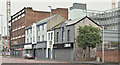
Nos 48-52 York Street, Belfast (December 2015)
The western side of York Street, between Frederick Street and Gt George’s Street.
Image: © Albert Bridge
Taken: 13 Dec 2015
0.02 miles
3
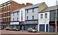
Nos 48-56 York Street, Belfast (April 2014)
Nos 48-56 York Street seen from near the corner of York Street Little Patrick Street. Image is on the left. 54 and 56 are not part of the proposed development but are included as future reference points.
Image: © Albert Bridge
Taken: 28 Apr 2014
0.02 miles
4
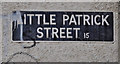
Little Patrick Street sign, Belfast
The white-on-black sign at the York Street end (southern side) of Little Patrick Street.
Image: © Albert Bridge
Taken: 29 Jun 2011
0.02 miles
5
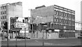
Co-op demolition, Belfast
Demolition of part of the Co-op, at the corner of Frederick Street and York Street (foreground). This allowed the corner of Frederick Street to be realigned in becoming part of the inner ring road (with the Dunbar Link). The wounded end of the Co was “bandaged” as seen in Image Frederick Street DHSS is on the left – see Image
Image: © Albert Bridge
Taken: 13 Jul 1983
0.02 miles
6
Nos 48-52 York Street, Belfast - June 2016(1)
The view from the corner of York Street and the Dunbar Link (Gt Patrick Street on the Google map).
Image: © Albert Bridge
Taken: 26 Jun 2016
0.02 miles
7
Nos 48-52 York Street, Belfast - June 2016(2)
The view from York Street towards Frederick Street. Northland House Image is at upper right.
Image: © Albert Bridge
Taken: 26 Jun 2016
0.02 miles
8
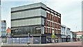
Nos 48-52 York Street, Belfast (May 2018)
The proposed redevelopment of these buildings, between Frederick Street (left) and Lancaster Street, has received planning permission. There is no sign (yet) of work starting.
Image: © Albert Bridge
Taken: 19 May 2018
0.02 miles
9
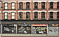
Nos 48-52 York Street, Belfast - February 2019(2)
The buildings now appear to be vacant. This is the former Co-op.
Image: © Albert Bridge
Taken: 23 Feb 2019
0.02 miles
10
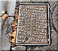
Manhole cover, Belfast
Glynwed Brickhouse cover in York Street, near Frederick Street.
Image: © Albert Bridge
Taken: 17 Aug 2010
0.02 miles