IMAGES TAKEN NEAR TO
Rosehead Drive, BELFAST, BT14 7BF
Introduction
This page details the photographs taken nearby to Rosehead Drive, BT14 7BF by members of the Geograph project.
The Geograph project started in 2005 with the aim of publishing, organising and preserving representative images for every square kilometre of Great Britain, Ireland and the Isle of Man.

There are currently over 7.5m images from over14,400 individuals and you can help contribute to the project by visiting https://www.geograph.org.uk
Image Map
Images are licensed for reuse under creativecommons.org/licenses/by-sa/2.0
Notes
- Clicking on the map will re-center to the selected point.
- The higher the marker number, the further away the image location is from the centre of the postcode.
Image Listing (32 Images Found)
Images are licensed for reuse under creativecommons.org/licenses/by-sa/2.0
Image
Details
Distance
1
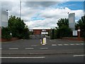
Gates of Hillview Retail Park, Crumlin Road
This failed retail park stands on the former site of the demolished Ewarts' Mill. It managed to attract only one permanent tenant - Dunnes Store - which eventually moved out. The park is now used for car boot sales.
http://www.nbin.info/index.php?option=com_content&task=view&id=41&Itemid=2
Image: © Eric Jones
Taken: 21 Jul 2014
0.12 miles
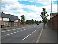
2
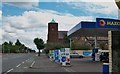
Maxol Service Station and Crumlin Road Presbyterian Church
Image: © Eric Jones
Taken: 21 Jul 2014
0.13 miles
3

Security concerns at Flax Street
Flax Street runs between a predominantly Protestant part of the Crumlin Road and the overwhelmingly Roman Catholic enclave of the Ardoyne - which in Northern Ireland terms can be a recipe for trouble. Therefore Flax Street now has a ten foot high gate, complete with spikes - and this simple sign dictate that it's a no-through road for 'security' reasons.
Image: © Dean Molyneaux
Taken: 26 Aug 2009
0.14 miles
4
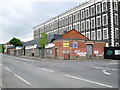
Dereliction, 333 Crumlin Road, Belfast
Beside Brookfield Mill and Flax Street on the Crumlin Road.
Image: © Dean Molyneaux
Taken: 26 Aug 2009
0.14 miles
5
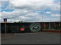
Interface barrier across the entrance to Flax Street
Flax Street was permanently closed in the 1980s. To this side of the barrier is Protestant Crumlin Road and the Greater Shankill area, behind it is the Catholic Ardoyne.
http://sluggerotoole.com/2011/05/28/potd-draw-down-the-walls/
Image: © Eric Jones
Taken: 21 Jul 2014
0.14 miles
6
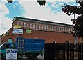
Former Brookfield Mill, Belfast
The former Brookfield Mill, on the Crumlin Road, built in 1850 and extended twice, is being converted to social housing. The occupants were variously known as the Brookfield Linen Co and the Brookfield Spinning Co Ltd. The date of closure seems to have been 1962 – a time when the linen industry was starting to contract. Last seen in August 2009 Image
Image: © Albert Bridge
Taken: 12 Nov 2013
0.16 miles
7

"Millie" statue, Belfast
A statue, by Ross Wilson, at the corner of Cambrai Street and the Crumlin Road, depicting a “millie” – a female mill worker. It was unveiled in May 2010.
Image: © Albert Bridge
Taken: 12 Nov 2013
0.16 miles
8
Crumlin Road approaching the junction with the now permanently closed Flax Road
Flax Road linked the Ardoyne and the Greater Shankill area. This road was a major flashpoint and since the 1980s a permanent interface barrier closes off the road.
Image: © Eric Jones
Taken: 21 Jul 2014
0.16 miles
9
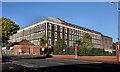
Edenderry Linen Mill, Crumlin Road
These extensive mill buildings date initially from 1865 with further additions in the period leading up to WWI. The main mill building has been converted into apartments and luxury penthouses. Another mill - Ewarts - stood on the opposite side of the Crumlin Road. This was demolished in 1999.
http://residential.btwshiells.com/KP/images/pdfs/64_671_94_ECS.pdf
Image
Image: © Eric Jones
Taken: 21 Jul 2014
0.16 miles
10

"Edenderry Gardens", Tennent Street, Belfast
This curious terrace on Tennent Street is called Edenderry Gardens - I think. From 266 to 294 Tennent Street.
Image: © Dean Molyneaux
Taken: 26 Aug 2009
0.17 miles