IMAGES TAKEN NEAR TO
Crumlin Road, BELFAST, BT14 6AH
Introduction
This page details the photographs taken nearby to Crumlin Road, BT14 6AH by members of the Geograph project.
The Geograph project started in 2005 with the aim of publishing, organising and preserving representative images for every square kilometre of Great Britain, Ireland and the Isle of Man.

There are currently over 7.5m images from over14,400 individuals and you can help contribute to the project by visiting https://www.geograph.org.uk
Image Map
Images are licensed for reuse under creativecommons.org/licenses/by-sa/2.0
Notes
- Clicking on the map will re-center to the selected point.
- The higher the marker number, the further away the image location is from the centre of the postcode.
Image Listing (101 Images Found)
Images are licensed for reuse under creativecommons.org/licenses/by-sa/2.0
Image
Details
Distance
1
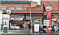
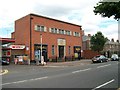
Spar and Star, Crumlin Road, Belfast (January 2017)
Star petrol station with a Spar shop at the corner of Landscape Terrace.
Image: © Albert Bridge
Taken: 15 Jan 2017
0.02 miles
2
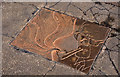
John Hewitt plaque, Belfast
A plaque, in the footpath, at the Crumlin Road end of Agnes Street commemorating the poet John Hewitt http://en.wikipedia.org/wiki/John_Hewitt_(poet). He was born nearby at Cliftonpark Avenue and attended Agnes Street Methodist Primary School.
Image: © Albert Bridge
Taken: 13 Sep 2011
0.02 miles
3
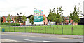
Site for social housing, Crumlin Road, Belfast (September 2014)
Vacant ground (once numbered, I think, 63-73) at the corner of the Crumlin Road (foreground) and Cliftonpark Avenue. The sign advises that it's the site for “High quality homes for the Lower Oldpark”. This photograph appears as a matter of geographical and historical record only. I have no connection with the Clanmill Housing Association.
Image: © Albert Bridge
Taken: 10 Sep 2014
0.02 miles
6
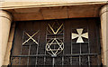
Masonic hall detail, Belfast
Listed as HB26/43/024, the Masonic Hall on the Crumlin Road was completed, in the Art Deco style, in 1940 to a design by John MacGeagh http://www.geograph.org.uk/search.php?i=24503674 . This detail is at the entrance.
Image: © Albert Bridge
Taken: 1 Sep 2011
0.03 miles
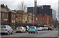
7

Cross roads on the Crumlin Road
Traffic from the left is entering from Cliftonpark Avenue, that from the right from Agnes Street. The buildings, from the left, include Crumlin Gaol, Freemasons Hall and the Mater Hospital
Image: © Eric Jones
Taken: 21 Jul 2014
0.03 miles
8
Freemason's Hall on Crumlin Road
This is situated next to the Crumlin Gaol. A number of lodges use this hall.
http://pglantrim.org/hallCrumlinRd.shtml
Image: © Eric Jones
Taken: 21 Jul 2014
0.04 miles
9
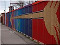
Colourful fence
This brightly coloured fence is at Crumlin Road Health Centre.
Image: © Paul McIlroy
Taken: 6 Mar 2008
0.05 miles
10
The Crumlin Road (3)
This picture shows two well known buildings on the Crumlin Road, the first one is the Crumlin Road Jail (no longer in use) and next to that is the Mater Hospital.
Image: © Paul McIlroy
Taken: 6 Mar 2008
0.05 miles