IMAGES TAKEN NEAR TO
Laganbank Road, BELFAST, BT1 3LY
Introduction
This page details the photographs taken nearby to Laganbank Road, BT1 3LY by members of the Geograph project.
The Geograph project started in 2005 with the aim of publishing, organising and preserving representative images for every square kilometre of Great Britain, Ireland and the Isle of Man.

There are currently over 7.5m images from over14,400 individuals and you can help contribute to the project by visiting https://www.geograph.org.uk
Image Map
Images are licensed for reuse under creativecommons.org/licenses/by-sa/2.0
Notes
- Clicking on the map will re-center to the selected point.
- The higher the marker number, the further away the image location is from the centre of the postcode.
Image Listing (991 Images Found)
Images are licensed for reuse under creativecommons.org/licenses/by-sa/2.0
Image
Details
Distance
1
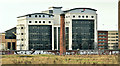
The Waterfront Plaza, Belfast (December 2018)
The Waterfront Plaza, from the Short Strand, across the still-vacant Sirocco site. This chimney Image is in the middle.
Image: © Albert Bridge
Taken: 16 Dec 2018
0.00 miles
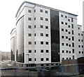
2
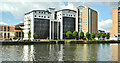
Price Waterhouse Coopers Building overlooking the River Lagan
These offices are located on Laganbank Road.
Image: © Eric Jones
Taken: 28 Mar 2017
0.01 miles
3

Cycle path post, Belfast
This Millennium National Cycle Path post is on the Laganbank Road. Continue to Image
Image: © Albert Bridge
Taken: 13 May 2008
0.01 miles
4
The Waterfront Plaza, Belfast - June 2018(1)
The building, in its present form, from the Laganside Walkway.
Image: © Albert Bridge
Taken: 16 Jun 2018
0.01 miles
5
The Waterfront Plaza, Belfast - June 2018(2)
The building, in its present form, from the Albert Bridge end of the Laganside Walkway. The BT Tower would be hidden if the proposed floors are built.
Image: © Albert Bridge
Taken: 16 Jun 2018
0.01 miles
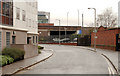
6
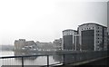
May's Meadow, Belfast (1)
No longer the meadow where cattle were kept before sale at the nearby market, May’s Meadow runs from the Laganbank Road to East Bridge Street via a tunnel (Image middle left) close to Central station. The station (top left) was in its original form Image The gasworks can be seen at upper right – now closed and redeveloped (after extensive decontamination) Image The railway is behind the concrete fence (right). For the 2010 view see Image
Image: © Albert Bridge
Taken: 21 Jun 1983
0.01 miles
7
May's Meadow, Belfast (2)
Image: © Albert Bridge
Taken: 24 Jan 2010
0.01 miles
8
Price Waterhouse Coopers Building, at the Waterfront Plaza
Image: © Eric Jones
Taken: 28 Mar 2017
0.01 miles
9
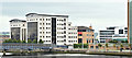
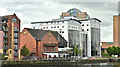
The Waterfront Plaza, Belfast (August 2018)
The view from the Queen’s Bridge.
Image: © Albert Bridge
Taken: 21 Aug 2018
0.01 miles
10
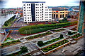
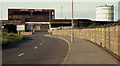
Public Garden next to Lagan River Walkway
Lanyon Place road (at right) passes under the rapid transit tracks and joins Laganbank Road (at left) or Mays Meadows road to the right in front of the white building behind the rapid transit tracks. The gardens are located next to the Hilton Hotel.
Image: © Joseph Mischyshyn
Taken: 22 Sep 2013
0.02 miles