IMAGES TAKEN NEAR TO
Victoria Street, BELFAST, BT1 3GL
Introduction
This page details the photographs taken nearby to Victoria Street, BT1 3GL by members of the Geograph project.
The Geograph project started in 2005 with the aim of publishing, organising and preserving representative images for every square kilometre of Great Britain, Ireland and the Isle of Man.

There are currently over 7.5m images from over14,400 individuals and you can help contribute to the project by visiting https://www.geograph.org.uk
Image Map
Images are licensed for reuse under creativecommons.org/licenses/by-sa/2.0
Notes
- Clicking on the map will re-center to the selected point.
- The higher the marker number, the further away the image location is from the centre of the postcode.
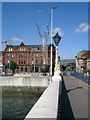
Image Listing (3179 Images Found)
Images are licensed for reuse under creativecommons.org/licenses/by-sa/2.0
Image
Details
Distance
1
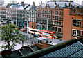
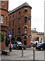
Victoria Street, Belfast (3)
All the buildings, in this view of Victoria Street, have now vanished. Those in the background were demolished as described in Image
Those in the foreground (including the building from which the photograph was taken) went under the bulldozer for the Victoria Square development Image
In the days before the Westlink Image and the M3 Image, all traffic from the south to the north and north Down passed along Victoria Street (much quieter now).
Finally, just below the double-deck bus, there was a security checkpoint where all vehicles and pedestrians, entering “The Segments” Image were searched.
There is no equivalent in 2011. This is an approximate “then and now” Image
Image: © Albert Bridge
Taken: 25 May 1976
0.00 miles
2
Demolition site, Victoria Street, Belfast (4)
See Image Three of the buildings almost opposite Victoria Square, to the right (south) of the previous photo. Continue to Image
Image: © Albert Bridge
Taken: 30 Oct 1988
0.00 miles
3
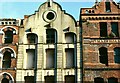
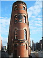
Former Trueman's warehouse, Belfast
This building, at the apex of Upper Church Lane and Victoria Street, displays this shamrock with the date “1861”. An architectural guide book gives the date of construction as 1868 . . . See also Image Image shows the entire building in March 2012.
Image: © Albert Bridge
Taken: 15 Jul 2007
0.01 miles
4
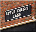
Street signs, Belfast (2)
See Image One of the less common, white on black signs with the old postal district number, on the south eastern side, at the Victoria Square end of Upper Church Lane.
Image: © Albert Bridge
Taken: 11 Oct 2009
0.01 miles
5
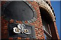
Bittles Bar
Bittles is a small bar, sitting at the sharp end of Belfast's only flat-iron building. It dates back to the 1860's and you can see a gilded shamrock about half way up.
Image: © Clive Thompson
Taken: 18 May 2008
0.01 miles
6
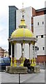
Young lovers at the Jaffe Fountain in Victoria Square
Image: © Eric Jones
Taken: 1 Jun 2011
0.01 miles
7
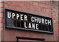
Street signs, Belfast (1)
A traditional tiled sign, on the south western side, at the Victoria Square end of Upper Church Lane. See also Image
Image: © Albert Bridge
Taken: 11 Oct 2009
0.02 miles
9
Sculpture
http://www.discovernorthernireland.com/article.aspx?ArticleID=859&Layout=Homepage
Image: © Paul McIlroy
Taken: 11 Jun 2006
0.02 miles
10

The Jaffe fountain, Belfast (3)
Image: © Albert Bridge
Taken: 1 Oct 2009
0.02 miles