IMAGES TAKEN NEAR TO
Queens Square, BELFAST, BT1 3FL
Introduction
This page details the photographs taken nearby to Queens Square, BT1 3FL by members of the Geograph project.
The Geograph project started in 2005 with the aim of publishing, organising and preserving representative images for every square kilometre of Great Britain, Ireland and the Isle of Man.

There are currently over 7.5m images from over14,400 individuals and you can help contribute to the project by visiting https://www.geograph.org.uk
Image Map
Images are licensed for reuse under creativecommons.org/licenses/by-sa/2.0
Notes
- Clicking on the map will re-center to the selected point.
- The higher the marker number, the further away the image location is from the centre of the postcode.
Image Listing (635 Images Found)
Images are licensed for reuse under creativecommons.org/licenses/by-sa/2.0
Image
Details
Distance
1
Sailortown, Belfast (3)
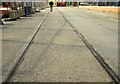
See Image There is so little left that it is next to impossible to give any worthwhile idea of how the area looked before the demolitions. This piece of old harbour railway, in Prince’s Dock Street, and the bar and sandwich shop (background) are about all that is left. See also Image
Image: © Albert Bridge
Taken: 24 Mar 2008
0.01 miles
2
Sailortown, Belfast (5)
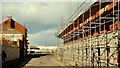
See Image These new houses are being built in Short Street.
Image: © Albert Bridge
Taken: 24 Mar 2008
0.02 miles
3
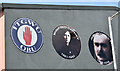
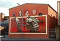
Trade unionist portraits, Pilot Street, Belfast - May 2016(1)
Portraits of famous Irish trade unionists on the wall of the Dockers Club, Pilot Street. This photograph appears as a matter of record only. I have no connection the club, any trade union or political party. Continue to Image
Image: © Albert Bridge
Taken: 14 May 2016
0.02 miles
4
Trade unionist portraits, Pilot Street, Belfast - May 2016(2)
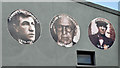
See Image Portraits of famous Irish trade unionists on the wall of the Dockers Club, Pilot Street. This photograph appears as a matter of record only. I have no connection the club, any trade union or political party.
Image: © Albert Bridge
Taken: 14 May 2016
0.02 miles
5
Pilot Place, Belfast
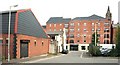
100 years ago Pilot Place had seven houses. This is today’s view towards Pilot Street Image The apartments (background) are being advertised as “Pilot Place”.
Image: © Albert Bridge
Taken: 23 Jul 2009
0.03 miles
6
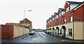
Short Street, Belfast (2)
See Image One for the record – the houses on the right are now occupied.
Image: © Albert Bridge
Taken: 19 Dec 2009
0.03 miles
7
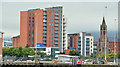
Pilot Street apartments, Belfast (5)
The existing development seen from near “Titanic Belfast”. The proposed “Olympic Tower” development has still to start.
Image: © Albert Bridge
Taken: 12 Sep 2013
0.03 miles
8

Sailortown, Belfast (4)
See Image This sculpture (already covered Image), at the main entrance to the harbour, provides a link to Sailortown’s maritime past.
Image: © Albert Bridge
Taken: 24 Mar 2008
0.03 miles
9
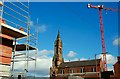
Sailortown, Belfast (1)
Sailortown is the local name for an area of Belfast bounded by York Street, Whitla Street, the harbour and Gt George’s Street. The residents had many close connections with the sea and docks. It fell victim to demolition for the M2/M3 motorways and has almost ceased to exist. There are major (private sector) redevelopments underway but for many the destruction was symbolised by the closure of St Joseph’s (RC) parish church (built in 1878-80) in 2001, an event not without acrimony between parishioners and hierarchy. Open-air masses are held each Sunday morning. This photo of the spire surrounded by the paraphernalia of building sites sums it all up. On the “At Risk” register.
Image: © Albert Bridge
Taken: 24 Mar 2008
0.03 miles
10
Sailortown, Belfast (2)
See Image Many residents worked in the docks in the days when labour was recruited daily. With no security of employment it was inevitable that there were strong links with Irish trade unionism. This poster, in Pilot Place, recalls an almost-forgotten era.
Image: © Albert Bridge
Taken: 24 Mar 2008
0.04 miles