IMAGES TAKEN NEAR TO
Queens Square, BELFAST, BT1 3FG
Introduction
This page details the photographs taken nearby to Queens Square, BT1 3FG by members of the Geograph project.
The Geograph project started in 2005 with the aim of publishing, organising and preserving representative images for every square kilometre of Great Britain, Ireland and the Isle of Man.

There are currently over 7.5m images from over14,400 individuals and you can help contribute to the project by visiting https://www.geograph.org.uk
Image Map
Images are licensed for reuse under creativecommons.org/licenses/by-sa/2.0
Notes
- Clicking on the map will re-center to the selected point.
- The higher the marker number, the further away the image location is from the centre of the postcode.
Image Listing (3426 Images Found)
Images are licensed for reuse under creativecommons.org/licenses/by-sa/2.0
Image
Details
Distance
1
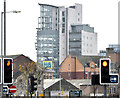
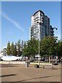
"The Boat", Belfast (November 2014)
The flat centre of Belfast and the general absence of “skyscrapers” makes the taller buildings noticeable, even from a distance. This view of “The Boat” (Donegall Quay) is from near the corner of Nelson Street and Gt Patrick Street.
Image: © Albert Bridge
Taken: 9 Nov 2014
0.00 miles
2
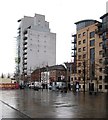
Modern multi-storey commencial and residential buildings in Queen's Square
The white building, whose front overlooks Donegall Quay, is known as "The Boat"
Image: © Eric Jones
Taken: 3 Nov 2014
0.00 miles
3
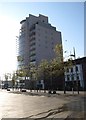
The Boat, Custom House Square
This is a tower block of high specification office accommodation.
http://www.osborneking.com/brochures/The%20Boat.pdf
Image: © Eric Jones
Taken: 21 May 2012
0.00 miles
4
"The Boat", Belfast (2013-1)
“The Boat” seen, across Donegall Quay, from beside The “Obel” Image – possibly (even probably) the most satisfactory way to appreciate this building at its best.
Image: © Albert Bridge
Taken: 30 Jan 2013
0.00 miles
5
"The Boat" and "The Big Fish"
"The Boat" is an office/apartment block.
Image: © Eric Jones
Taken: 21 May 2012
0.01 miles
6
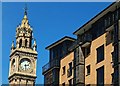
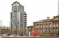
The leaning Albert Clock, Belfast
To understand the reason for the clock’s lean you have to remember that it is built on reclaimed land and that ships once berthed at the bottom of Waring Street Image and High Street Image - Skipper Street Image also refers to this. Much of central Belfast is underlain by a deposit of soft mud and silt - "sleech".
Inst Image and the Custom House Image are two buildings which are now lower than when built as a result of sinking into the sleech.
The cross-harbour road and railway Image Image Image required foundations up to 60 metres deep before reaching firm ground.
The clock is said to be 113 ft tall and to be 14ft off vertical (it was built to imperial measurements). The degree of lean can be appreciated in this comparison with the Custom House Square apartments Image completed this year. Image shows, for comparison, the view from the east.
Image: © Albert Bridge
Taken: 31 May 2009
0.01 miles
7
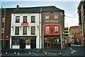
McHughs Bar, Belfast
Built between 1710 and 1720, McHughs is officially the oldest building in the city of Belfast,
Image: © Graham Hogg
Taken: 29 Oct 2002
0.01 miles
8
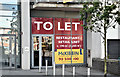
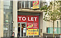
Restaurant to let, Queen's Square, Belfast (September 2016)
A vacant unit, on the ground floor of The Boat, with a “to let” sign. I have no connection with any of the parties involved in the letting.
Image: © Albert Bridge
Taken: 30 Sep 2016
0.01 miles
9
Proposed restaurant, Queen's Square, Belfast (September 2018)
Now with a “let” sign, this unit, on the ground floor of The Boat, has been vacant since completion. The agents use the number 49 Queen’s Square for the entire building.
I have no connection with the proposed business.
Image: © Albert Bridge
Taken: 30 Sep 2018
0.01 miles
10
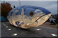
The "Big Fish", Donegall Quay, Belfast
Another photo of the ever-popular “Big Fish” but by artificial light. Continue to Image
Image: © Albert Bridge
Taken: 11 Oct 2007
0.01 miles