IMAGES TAKEN NEAR TO
Pilot Street, BELFAST, BT1 3EZ
Introduction
This page details the photographs taken nearby to Pilot Street, BT1 3EZ by members of the Geograph project.
The Geograph project started in 2005 with the aim of publishing, organising and preserving representative images for every square kilometre of Great Britain, Ireland and the Isle of Man.

There are currently over 7.5m images from over14,400 individuals and you can help contribute to the project by visiting https://www.geograph.org.uk
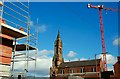
Image Map
Images are licensed for reuse under creativecommons.org/licenses/by-sa/2.0
Notes
- Clicking on the map will re-center to the selected point.
- The higher the marker number, the further away the image location is from the centre of the postcode.
Image Listing (645 Images Found)
Images are licensed for reuse under creativecommons.org/licenses/by-sa/2.0
Image
Details
Distance
1
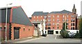
Pilot Place, Belfast
100 years ago Pilot Place had seven houses. This is today’s view towards Pilot Street Image The apartments (background) are being advertised as “Pilot Place”.
Image: © Albert Bridge
Taken: 23 Jul 2009
0.01 miles
2
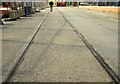
Sailortown, Belfast (3)
See Image There is so little left that it is next to impossible to give any worthwhile idea of how the area looked before the demolitions. This piece of old harbour railway, in Prince’s Dock Street, and the bar and sandwich shop (background) are about all that is left. See also Image
Image: © Albert Bridge
Taken: 24 Mar 2008
0.01 miles
3
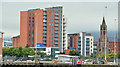
Pilot Street apartments, Belfast (5)
The existing development seen from near “Titanic Belfast”. The proposed “Olympic Tower” development has still to start.
Image: © Albert Bridge
Taken: 12 Sep 2013
0.02 miles
4
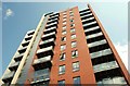
Pilot Street apartments, Belfast (2)
See Image There is still quite a bit of activity around the site. The building, however (to the layman), seems to be nearing completion.
Image: © Albert Bridge
Taken: 23 Jul 2009
0.02 miles
5

Former St Joseph's church, Belfast (1)
See Image The former parochial house, in Pilot Street Image, was completed in 1879 to a design by Mortimer Thompson (Timothy Hevey designed the church). It now lies empty and forlorn. On the “At Risk” register. Continue to Image
Image: © Albert Bridge
Taken: 23 Jul 2009
0.02 miles
6
Sailortown, Belfast (1)
Sailortown is the local name for an area of Belfast bounded by York Street, Whitla Street, the harbour and Gt George’s Street. The residents had many close connections with the sea and docks. It fell victim to demolition for the M2/M3 motorways and has almost ceased to exist. There are major (private sector) redevelopments underway but for many the destruction was symbolised by the closure of St Joseph’s (RC) parish church (built in 1878-80) in 2001, an event not without acrimony between parishioners and hierarchy. Open-air masses are held each Sunday morning. This photo of the spire surrounded by the paraphernalia of building sites sums it all up. On the “At Risk” register.
Image: © Albert Bridge
Taken: 24 Mar 2008
0.02 miles
7

Former St Joseph's church, Belfast (2)
See Image The spire, with weeds growing from the tower. On the “At Risk” register. Continue to Image
Image: © Albert Bridge
Taken: 23 Jul 2009
0.03 miles
8
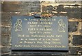
Former St Joseph's church, Belfast (3)
See Image A self-explanatory plaque on the Prince’s Dock Street façade of the disused church. Continue to Image
Image: © Albert Bridge
Taken: 23 Jul 2009
0.03 miles
9
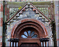
Former St Joseph's church, Belfast (4)
See Image The former entrance from Prince’s Dock Street (Prince’s Dock Road on the Google map). Continue to Image
Image: © Albert Bridge
Taken: 4 May 2011
0.03 miles
10
Former St Joseph's church, Belfast (5)
Image: © Albert Bridge
Taken: 4 May 2011
0.03 miles