IMAGES TAKEN NEAR TO
Corporation Street, BELFAST, BT1 3DH
Introduction
This page details the photographs taken nearby to Corporation Street, BT1 3DH by members of the Geograph project.
The Geograph project started in 2005 with the aim of publishing, organising and preserving representative images for every square kilometre of Great Britain, Ireland and the Isle of Man.

There are currently over 7.5m images from over14,400 individuals and you can help contribute to the project by visiting https://www.geograph.org.uk
Image Map
Images are licensed for reuse under creativecommons.org/licenses/by-sa/2.0
Notes
- Clicking on the map will re-center to the selected point.
- The higher the marker number, the further away the image location is from the centre of the postcode.
Image Listing (554 Images Found)
Images are licensed for reuse under creativecommons.org/licenses/by-sa/2.0
Image
Details
Distance
2
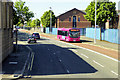
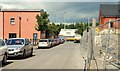
Corporation Street, Belfast (1)
Corporation Street runs towards the city centre from near the entrance to the harbour (there is a ship in the Pollock Dock at middle right). It is currently closed to through traffic to facilitate the renewal of the Belfast sewers). Continue to Image
Image: © Albert Bridge
Taken: 21 Oct 2007
0.03 miles
3
Pilot Street, Belfast (March 2016)
Pilot Street from Garmoyle Street/Corporation Street looking very similar to this view Image in February 2010. On 29 March 2016 the Department for Social Development published a draft Sailortown Masterplan for consultation “The Draft Masterplan has been created to provide an overarching framework for the future development of Sailortown - an exciting future destination adjacent to City Quays north of Belfast City Centre.”
I have no connection with the Department and cannot enter into correspondence.
Image: © Albert Bridge
Taken: 30 Mar 2016
0.04 miles
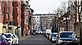
4
Trafalgar Street, Belfast
The name recalls the battle in 1809. The street existed by 1819 and eventually contained 63 houses. It fell victim to the widespread demolition for the elevated ring road, only part of which was ever built. Now just a line between buildings. See also Image
Image: © Albert Bridge
Taken: 17 May 2009
0.04 miles
5

Street sign, Belfast
A damaged (and suitably amended wall) street sign in Trafalgar Street Image
Image: © Albert Bridge
Taken: 26 Jul 2009
0.05 miles
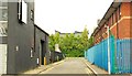
6
Pilot Street, Belfast
See Image What’s left of Pilot Street (looking towards Corporation Street) with the new apartments site Image behind the fence (right). See also Image
Image: © Albert Bridge
Taken: 23 Jul 2009
0.05 miles
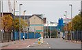
7
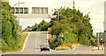
The Nelson Street off-slip, Belfast
The main exit from the M2 Image to the city centre, it achieves daily fame on the morning traffic reports – very quiet, however, on a Sunday morning. Continue to Image
Image: © Albert Bridge
Taken: 12 Jul 2009
0.05 miles
8
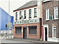
McKenna's Bar, Garmoyle Street, Belfast (September 2016)
McKenna’s Bar at the corner of Dock Street and Garmoyle Street (foreground) – previously McMahon’s Image (April 2014). It was Turley’s in 1918 and O’Boyle’s in 1901. I have no connection with the business.
Image: © Albert Bridge
Taken: 8 Sep 2016
0.05 miles
9
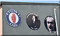
Trade unionist portraits, Pilot Street, Belfast - May 2016(1)
Portraits of famous Irish trade unionists on the wall of the Dockers Club, Pilot Street. This photograph appears as a matter of record only. I have no connection the club, any trade union or political party. Continue to Image
Image: © Albert Bridge
Taken: 14 May 2016
0.05 miles
10
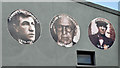
Trade unionist portraits, Pilot Street, Belfast - May 2016(2)
See Image Portraits of famous Irish trade unionists on the wall of the Dockers Club, Pilot Street. This photograph appears as a matter of record only. I have no connection the club, any trade union or political party.
Image: © Albert Bridge
Taken: 14 May 2016
0.05 miles