1
"The Dividers", Belfast
“The Dividers” is a sculpture by Vivien Burnside erected in 2002 close to the Clarendon Dock. According to the official blurb it “stands as an archway or frame as the viewer looks inwards to the changing city or outwards to the sea. Dividers, in connecting points, allude to communication and navigation intrinsic to the Clarendon Dock area”. Imbued with that knowledge you may now sleep soundly.
Image: © Albert Bridge
Taken: 24 Mar 2008
0.00 miles
2
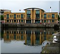
The Clarendon Dock, Belfast (October 2016)
The Clarendon Dock was a development, spanning the late 20th and early 21st centuries, on surplus and disused harbour land to the north of Donegall Quay. This is the northern end, seen across the dock, looking towards the Pilot Street Apartments http://www.geograph.org.uk/snippet/9711 (background).
Image: © Albert Bridge
Taken: 30 Oct 2016
0.01 miles
3
The Clarendon Dock, Belfast (3)
See
Image The view to the north showing how the area was redeveloped.
Image: © Albert Bridge
Taken: 21 Oct 2007
0.01 miles
4
The Clarendon Dock, Belfast (2)
See
Image The view to the NE showing how the area was redeveloped.
Image: © Albert Bridge
Taken: 21 Oct 2007
0.02 miles
5
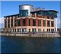
Modern building, Clarendon Dock, Belfast
The area around Clarendon Dock, dilapidated since the 1970s, was heavily redeveloped under the 'Laganside' scheme in the 1990s. This modern office building is indicative of the new landscape. See also
Image
Image: © Rossographer
Taken: 28 Jun 2008
0.03 miles
6
Bench Mark, Belfast
A brass bolt bench mark, it is located approximately 1 metre to the south-east of the lock gates to Clarendon Dry Dock No.2
Image It is marked "OS BM".
The mark is 2.51 metres above MSL.
See also http://www.geograph.org.uk/search.php?i=11037856 for many other examples I have found.
This mark is important in the history of geodetic levelling by the Ordnance Survey Northern Ireland. Prior to a new geodetic levelling of Northern Ireland in 1957, all levels in Ireland, north and south, related to Poolbeg Datum. The completion of the 1950s levelling necessitated a new vertical datum for N.Ireland. Thus, the establishment of a new Mean Sea Level (MSL) for Belfast was created through a lengthy series of tidal observations made at Belfast by the Harbour Board between 1951-56 and this data was shared with OSNI. A tidal gauge at Clarendon Dock was used for the observations; the relationship between the levels on the gauge and a Fundamental Bench Mark at the Grove Playing Fields in Belfast was established via this bolt on the dockside. Thus all levelling data produced on large scale maps by OSNI since the 1960s give height above MSL Belfast (smaller scale maps, such as the 1:50,000 series, refer to MSL Malin in order to ensure compatability throughout Ireland).
The information above is taken from sources produced by OSNI (previouisly available online but since deleted).
Image: © Rossographer
Taken: 14 Apr 2010
0.03 miles
7
The Clarendon Dock, Belfast (6)
See
Image The former workshops, during restoration in 1991.
Image: © Albert Bridge
Taken: 28 Jul 1991
0.03 miles
8
Modern building, Clarendon Dock, Belfast
The area around Clarendon Dock, dilapidated since the 1970s, was heavily redeveloped under the 'Laganside' scheme in the 1990s. This modern office building is indicative of the new landscape. See also
Image
Image: © Rossographer
Taken: 25 Jun 2008
0.04 miles
9
"Charlotte Rhodes" in Belfast
Star of the 1970s BBC television series “The Onedin Line”, the “Charlotte Rhodes” was a three-masted topsail schooner. She got into difficulties off Belfast Lough on 27 September 1975 and, with assistance from the Donaghadee Lifeboat, put in to Belfast for repairs. Dry-docked in Belfast Harbour Commissioners No. 2 Graving Dock, repairs were undertaken by A W Hamilton & Co Limited and “Charlotte Rhodes” returned to Dartmouth in mid-October. She was lost some time in the 1980s.
Most of the Belfast harbour area was closed to the public in the 1970s and patrolled by the Harbour Police. Photograph was taken with assistance from A W Hamilton & Co Limited.
Given the passage of time and significant changes to the area, location is the best I can do.
Image: © The Carlisle Kid
Taken: 30 Sep 1975
0.04 miles
10
Dry Dock 2, Clarendon Dock, Belfast
Located beside
Image and almost as old, dating from 1826. It is still in full working order and operated using hand driven winches and pulleys - see
Image
The dock is still used, albeit rarely, for ship repair. The ‘Victoria’ (see
Image), a ship used for survey work and to help maintain navigation lights and fog horns on the approaches to the Port, is inspected and repaired tri-annually in the dock. See another view at
Image
Image: © Rossographer
Taken: 28 Jun 2008
0.04 miles


