IMAGES TAKEN NEAR TO
Chief Street, BELFAST, BT13 3JE
Introduction
This page details the photographs taken nearby to Chief Street, BT13 3JE by members of the Geograph project.
The Geograph project started in 2005 with the aim of publishing, organising and preserving representative images for every square kilometre of Great Britain, Ireland and the Isle of Man.

There are currently over 7.5m images from over14,400 individuals and you can help contribute to the project by visiting https://www.geograph.org.uk
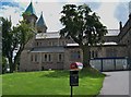
Image Map
Images are licensed for reuse under creativecommons.org/licenses/by-sa/2.0
Notes
- Clicking on the map will re-center to the selected point.
- The higher the marker number, the further away the image location is from the centre of the postcode.
Image Listing (66 Images Found)
Images are licensed for reuse under creativecommons.org/licenses/by-sa/2.0
Image
Details
Distance
1
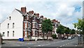
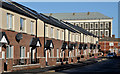
Three storeyed Victorian terrace on Woodvale Road
Image: © Eric Jones
Taken: 21 Jul 2014
0.07 miles
2
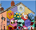
Playground mural, Belfast
A mural, showing scenes from the world of nature, near the corner of Disraeli Street and Ohio Street.
Image: © Albert Bridge
Taken: 12 Nov 2013
0.08 miles
3
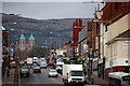
Woodvale Parade viewed from Woodvale Road
The transmitter masts on Divis can be seen in the background. Woodvale Parade has housing dating mainly from the post-WWII period.
Image: © Eric Jones
Taken: 21 Jul 2014
0.09 miles
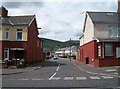
4
Disraeli Street, Belfast
Disraeli Street presents an interesting example of the growth of Belfast in the late 19th century. In 1877 it had 18 houses off the Crumlin Road. In 1890 there were 51. They increased to more than 160 by 1901 when it extended south to Woodvale Street. This is the recently rebuilt western side, seen from Ohio Street close to Leopold Street Image It now turns left and no longer runs through to the Crumlin Road. For reference purposes the former Brookfield Mill Image is at top right.
Image: © Albert Bridge
Taken: 12 Nov 2013
0.09 miles
5
Bray Street in the Greater Shankill
This is an area of Victorian terraced housing built in what then used to be the outskirts of 19thC Belfast.
Image: © Eric Jones
Taken: 21 Jul 2014
0.11 miles
6
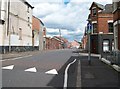
The Crumlin Road (2)
Looking towards Ardoyne, the church with the twin spires is Holy Cross Ardoyne, and the hill in the background is Wolf Hill.
Image: © Paul McIlroy
Taken: 6 Mar 2008
0.12 miles
7
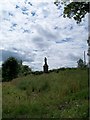
Statue of St Gabriel in the grounds of Holy Cross Church
The inscription states it was commissioned by a grateful client of St Gabriel for the good of the client and the people of the Ardoyne. The statue stands in an area of rough land south of the church known as the Grove.
Image: © Eric Jones
Taken: 21 Jul 2014
0.12 miles
8

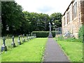
Passionist burial plot next to Holy Cross Church
Image: © Eric Jones
Taken: 21 Jul 2014
0.12 miles
9
Passionists' burial plot at Holy Cross Church, Ardoyne
These are the only burials in the graveyard.
Image: © Eric Jones
Taken: 21 Jul 2014
0.12 miles