IMAGES TAKEN NEAR TO
Upper Riga Street, BELFAST, BT13 3GW

Introduction

This page details the photographs taken nearby to Upper Riga Street, BT13 3GW by members of the Geograph project.

The Geograph project started in 2005 with the aim of publishing, organising and preserving representative images for every square kilometre of Great Britain, Ireland and the Isle of Man.

There are currently over 7.5m images from over14,400 individuals and you can help contribute to the project by visiting https://www.geograph.org.uk

Image Map


Images are licensed for reuse under creativecommons.org/licenses/by-sa/2.0
Notes
  • Clicking on the map will re-center to the selected point.
  • The higher the marker number, the further away the image location is from the centre of the postcode.

Image Listing (119 Images Found)

Images are licensed for reuse under creativecommons.org/licenses/by-sa/2.0
  • ...
Image
Details
Distance
1
Acton Street, Belfast
This is what the whole Shankill area used to look like - row upon row of 'two-up-two-down' houses. This cluster off Tennent Street are some of the last remaining - some are lying derelict. Glenwood Primary School is at the end of the street.
Image: © Dean Molyneaux Taken: 26 Aug 2009
0.03 miles
2
Orkney Street, Belfast
Runs between Upper Riga Street and Bootle Street in the Shankill area. A reminder of what Belfast streets used to look like.
Image: © Dean Molyneaux Taken: 26 Aug 2009
0.04 miles
3
Sign, Acton Street, Belfast
At the corner with Eccles Street. Likely original to the street - now somewhat rusted. I'm less keen on the pebble dashed wall - the old red brick looks far better in my opinion.
Image: © Dean Molyneaux Taken: 26 Aug 2009
0.06 miles
4
Shankill Baptist Church
On Tennent Street - quite ornate as Baptist in Ireland churches go.
Image: © Dean Molyneaux Taken: 26 Aug 2009
0.06 miles
5
Tennent Street, Belfast
This links the Shankill Road and the Crumlin Road. It has only been partially redeveloped - note the original terrace to the right.
Image: © Dean Molyneaux Taken: 26 Aug 2009
0.07 miles
6
Shankill Road at Lanark Way
Lanark Way (to right) link the Shankill with the Springfield Road - an interface area.
Image: © Dean Molyneaux Taken: 25 Aug 2009
0.07 miles
7
Tennent Street, off the Shankill Road
This a residential street off Shankill Road. The Shankill Baptist Church on the left was completed in 1906.
Image: © Eric Jones Taken: 21 Jul 2014
0.07 miles
8
Shankill Baptist church, Belfast - December 2014(1)
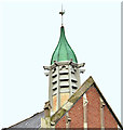
A church, at the Shankill Road end of Tennent Street, completed in 1906 to a design by James Hanna who also designed the nearby Baptist church at Cliftonpark Avenue Image Previously seen in Image (August 2009) and Image (July 2014). More information about the church may be found here http://shankillbaptist.com/. Image shows the lantern and weathervane.
Image: © Albert Bridge Taken: 16 Dec 2014
0.07 miles
9
Shankill Baptist church, Belfast - December 2014(2)
See Image A lantern topped by a weathervane.
Image: © Albert Bridge Taken: 16 Dec 2014
0.07 miles
10
John McIlwrath headstone, Shankill Graveyard, Belfast (March 2016)
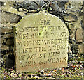
An exceptionally well-preserved headstone, in the Shankill Graveyard, now placed against a boundary wall. The inscription reads “Here lyeth the body of John McLWrath [sic] who departed this life the 27 day of August 1719 aged 66 years”.
Image: © Albert Bridge Taken: 3 Mar 2016
0.07 miles
  • ...