IMAGES TAKEN NEAR TO
Kilmore Close, BELFAST, BT13 2TE
Introduction
This page details the photographs taken nearby to Kilmore Close, BT13 2TE by members of the Geograph project.
The Geograph project started in 2005 with the aim of publishing, organising and preserving representative images for every square kilometre of Great Britain, Ireland and the Isle of Man.

There are currently over 7.5m images from over14,400 individuals and you can help contribute to the project by visiting https://www.geograph.org.uk
Image Map
Images are licensed for reuse under creativecommons.org/licenses/by-sa/2.0
Notes
- Clicking on the map will re-center to the selected point.
- The higher the marker number, the further away the image location is from the centre of the postcode.
Image Listing (71 Images Found)
Images are licensed for reuse under creativecommons.org/licenses/by-sa/2.0
Image
Details
Distance
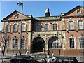
1
Clonard Monastery Youth Centre, Belfast
More at http://www.clonard.com/about.html
Image: © Kenneth Allen
Taken: 8 Mar 2010
0.09 miles
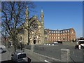
2
Clonard Monastery
Taken from the roof of the old North Howard Street Mill
Image: © Rob Taylor
Taken: 21 Jun 1978
0.10 miles
3
Belfast, former mill
On Sevastopol Street; a former flax mill, now residential.
Image: © Mike Faherty
Taken: 21 Apr 2018
0.10 miles
4
West Belfast, Peace Wall and Clonard Monastery
One of the most prominent peace walls separates the nationalist Falls Road and unionist Shankill areas of West Belfast. Almost twenty years after the Good Friday Agreement of 1998 https://en.wikipedia.org/wiki/Good_Friday_Agreement , it is saddening to see this that this huge wall still stretches across the city to divide it. The Northern Ireland Executive has committed to the removal of this and the other peace walls by 2023 (http://www.irishtimes.com/news/robinson-and-mcguinness-want-peace-walls-down-within-10-years-1.1388183 The Irish Times); in the meantime, the wall has become something of a tourist attraction.
This view is from the Loyalist side of the wall. The large church on the other side is the Catholic Clonard Monastery, just off the Falls Road.
Image: © David Dixon
Taken: 26 May 2017
0.11 miles
5
Clonard RC Church, Belfast
Pictured along the Springfield Road
Image: © Kenneth Allen
Taken: 8 Mar 2010
0.11 miles
7
Corner of Kashmir Road and Clonard Gardens, Belfast
Image: © Robert Eva
Taken: 5 Aug 2017
0.13 miles
8
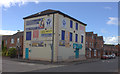
Belfast Public Library
Carnegie Branch Falls Road
Image: © Kenneth Allen
Taken: 8 Mar 2010
0.13 miles
9
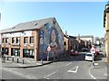
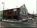
Murals, West Belfast (9)
It is located at the junction of Clonard Street and Falls Road
Image: © Kenneth Allen
Taken: 8 Mar 2010
0.14 miles
10
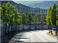
The Peace Wall, Cupar Way
One of the most prominent peace walls separates the nationalist Falls Road and unionist Shankill areas of West Belfast. Almost twenty years after the Good Friday Agreement of 1998 https://en.wikipedia.org/wiki/Good_Friday_Agreement , it is saddening to see this that this huge wall still stretches across the city to divide it.
The Northern Ireland Executive has committed to the removal of this and the other peace walls by 2023 (http://www.irishtimes.com/news/robinson-and-mcguinness-want-peace-walls-down-within-10-years-1.1388183 The Irish Times); in the meantime, the wall has become something of a tourist attraction. The best viewing section is on the Shankill side where visitors are encouraged to add their signatures to those of the Dalai Lama and former US President Clinton. Art panels showing the area's political and cultural history have now been added to the wall along Cupar Way.
Image: © David Dixon
Taken: 26 May 2017
0.15 miles