IMAGES TAKEN NEAR TO
Sherbrook Close, BELFAST, BT13 1ER
Introduction
This page details the photographs taken nearby to Sherbrook Close, BT13 1ER by members of the Geograph project.
The Geograph project started in 2005 with the aim of publishing, organising and preserving representative images for every square kilometre of Great Britain, Ireland and the Isle of Man.

There are currently over 7.5m images from over14,400 individuals and you can help contribute to the project by visiting https://www.geograph.org.uk
Image Map
Images are licensed for reuse under creativecommons.org/licenses/by-sa/2.0
Notes
- Clicking on the map will re-center to the selected point.
- The higher the marker number, the further away the image location is from the centre of the postcode.
Image Listing (188 Images Found)
Images are licensed for reuse under creativecommons.org/licenses/by-sa/2.0
Image
Details
Distance
1
The Growing Garden in Denmark Street
This is a lower Shankill community development iniative whereby vacant land in Denmark Street near the interface fence has been converted into gardening space. The project includes the providion of an outdoor classroom, community growing strips and informal play areas.
http://www.newsletter.co.uk/news/regional/fruit-and-veg-to-replace-eyesore-1-5941019
Image: © Eric Jones
Taken: 10 Jul 2015
0.03 miles
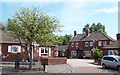
2
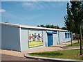
Denmark Street Community Centre in the Lower Shankill
Image: © Eric Jones
Taken: 10 Jul 2015
0.04 miles
3
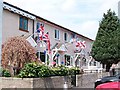
Twelfth of July bunting in Denmark Street
Denmark Street is close to the interface between the Loyalist Lower Shankill and the Nationalist New Lodge areas.
Image: © Eric Jones
Taken: 10 Jul 2015
0.05 miles
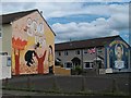
4
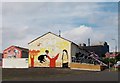
The Gold Rush mural off Denmark Street
The black glass sided block in the background is the Mater Hospital in the Crumlin Road.
Image: © Eric Jones
Taken: 10 Jul 2015
0.06 miles
5
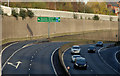
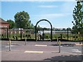
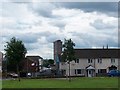
The Westlink, Belfast (4)
See Image The view towards the M2 and Clifton Street from the flyover at Peter’s Hill. Note the absence of goods vehicles on a Sunday morning. The northbound carriageway (left) was closed from Divis Street. Continue to Image
Image: © Albert Bridge
Taken: 15 Nov 2009
0.07 miles
6
Houses on the east side of Denmark Street
Image: © Eric Jones
Taken: 10 Jul 2015
0.07 miles
7
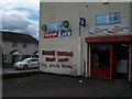
Warning to Drug Pedlars in the Lower Shankill
Image: © Eric Jones
Taken: 21 Jul 2014
0.07 miles
8
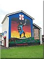
Cuchulainn Mural on the shop at Shankill Parade
Image: © Eric Jones
Taken: 21 Jul 2014
0.07 miles
9
The Nationalist Divis Tower towering above the low rise housing estates of the Loyalist Lower Shankill
The Divis Tower built in 1963 pre-dates the modern low rise estates off both the Shankill and the Falls Roads.
Image
Image: © Eric Jones
Taken: 21 Jul 2014
0.08 miles
10
The non-aligned " '69 Gold Rush" mural in Hopewell Crescent,
1869 saw a gold rush in both California and Scotland. As a part of Re-imaging Communities Programme this non-aligned mural of 2009 replaced an earlier Loyalist'Scottish Brigade' mural.
http://www.thetravelyear.com/gallery/photos/ire701_belfast_mural_scottish_brigade
Image: © Eric Jones
Taken: 21 Jul 2014
0.09 miles