IMAGES TAKEN NEAR TO
Clifton Street, BELFAST, BT13 1AB
Introduction
This page details the photographs taken nearby to Clifton Street, BT13 1AB by members of the Geograph project.
The Geograph project started in 2005 with the aim of publishing, organising and preserving representative images for every square kilometre of Great Britain, Ireland and the Isle of Man.

There are currently over 7.5m images from over14,400 individuals and you can help contribute to the project by visiting https://www.geograph.org.uk
Image Map
Images are licensed for reuse under creativecommons.org/licenses/by-sa/2.0
Notes
- Clicking on the map will re-center to the selected point.
- The higher the marker number, the further away the image location is from the centre of the postcode.
Image Listing (250 Images Found)
Images are licensed for reuse under creativecommons.org/licenses/by-sa/2.0
Image
Details
Distance
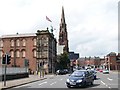
1
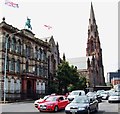
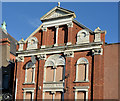
Clifton Street Orange Hall and the Carlisle Memorial Methodist Church
The Orange Hall (surmounted by a statue of King William III, the Union flag and the Northern Ireland flag) dates from 1887 and is built of igneous Newtownards stone with decorations in red Dumfries stone. Next door is the church hall of the former Carlisle Memorial Church which is used as a centre by Belfast's Indian community. The third building is the steepled former Carlisle Memorial Church, in its day Ireland's biggest Methodist church.
http://www.belfastbuildingstrust.org/carlisle.php
Image: © Eric Jones
Taken: 10 Jul 2015
0.01 miles
2
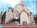
The rear of the Belfast Indian Community Centre
For many decades the Indian community was Belfast's largest ethnic community. The centre is housed in the vestry of the former Carlisle Memorial Methodist Church.
http://www.culturenorthernireland.org/features/heritage/indian-community-northern-ireland
Image: © Eric Jones
Taken: 10 Jul 2015
0.01 miles
3
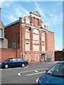
The boarded up rear of the Clifton Street Orange Hall
This building dates from 1887 and sited in one of the most troubled part of Belfast is subject to tit for tat vandalism from across the Peace Line.
http://www.irishnews.com/news/2015/06/28/news/clifton-street-orange-hall-attacked-153048/
Image: © Eric Jones
Taken: 10 Jul 2015
0.01 miles
4
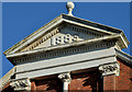
Clifton Street Orange Hall, Belfast (1)
A spherical finial topping a pediment enclosing the date of completion (1883), at the back of the building (Regent Street).
Image: © Albert Bridge
Taken: 24 Oct 2013
0.02 miles
5
Clifton Street Orange Hall, Belfast (2)
The back of the hall (Regent Street) incorporates much detail, a standard practice on Victorian buildings in Belfast, including this Image (top).
Image: © Albert Bridge
Taken: 24 Oct 2013
0.02 miles
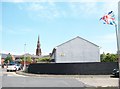
6
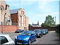
The rear of the Clifton Street Orange Hall
The rear of the building is in what used to be the northern end of Regent Street. The building of the Westlink urban motorway made this section of road a cul-de-sac.
Image: © Eric Jones
Taken: 10 Jul 2015
0.02 miles
8
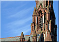
Former Carlisle memorial church, Belfast (4)
Part of the roof, tower and spire seen from Henry Place, Carlisle Circus. To the laymen the church still seems to be in a reasonable state of structural repair though there will, doubtless, be a considerable amount of work required to restore the building to its former glory. Charlie Brett considered “it must have a fighting claim to be Belfast’s ugliest church”.
Image: © Albert Bridge
Taken: 24 Oct 2013
0.02 miles
9
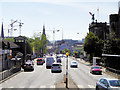
Clifton Street between the Westlink bridge and Carlisle Circus
The building flying the huge union flag is the Clifton Street Orange Hall and the steeple is that of the former Carlisle Memorial Methodist Church.
Image: © Eric Jones
Taken: 10 Jul 2015
0.02 miles
10
The steeple of the former Carlisle Memorial Methodist Church viewed from Hopewell Crescent
The buildings on the left are part of the Clifton Nursing Home.
Image: © Eric Jones
Taken: 10 Jul 2015
0.02 miles