IMAGES TAKEN NEAR TO
High Street, BELFAST, BT1 2BE
Introduction
This page details the photographs taken nearby to High Street, BT1 2BE by members of the Geograph project.
The Geograph project started in 2005 with the aim of publishing, organising and preserving representative images for every square kilometre of Great Britain, Ireland and the Isle of Man.

There are currently over 7.5m images from over14,400 individuals and you can help contribute to the project by visiting https://www.geograph.org.uk
Image Map
Images are licensed for reuse under creativecommons.org/licenses/by-sa/2.0
Notes
- Clicking on the map will re-center to the selected point.
- The higher the marker number, the further away the image location is from the centre of the postcode.
Image Listing (3499 Images Found)
Images are licensed for reuse under creativecommons.org/licenses/by-sa/2.0
Image
Details
Distance
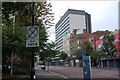
1
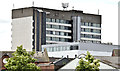
River House, Belfast (June 2014)
The forgotten view of this office block – the back seen from the Dunbar Link/Corporation Street. It also shows how River House dominates the surrounding lower buildings.
Image: © Albert Bridge
Taken: 19 Jun 2014
0.00 miles
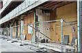
2
River House, Belfast (December 2017)
The High Street side, more than half of which remains hidden behind scaffolding and plastic sheeting.
Image: © Albert Bridge
Taken: 31 Dec 2017
0.00 miles
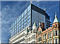
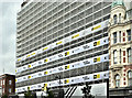
3
River House, Belfast (January 2018)
Most of the new façade is now on view.
Image: © Albert Bridge
Taken: 28 Jan 2018
0.00 miles
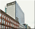
4
River House, Belfast (March 2018)
Most of the renovated and re-clad building is now on view.
Image: © Albert Bridge
Taken: 4 Mar 2018
0.00 miles
5
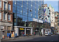
High Street, Belfast
Part of High Street in Belfast showing the recently redeveloped River House http://www.geograph.org.uk/search.php?i=111028152 .
Image: © Rossographer
Taken: 26 Feb 2020
0.00 miles
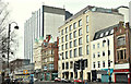
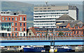
6
River House, Belfast (September 2007)
River House, in High Street, was built in the early 70’s. The land had been vacant since WWII when much of High Street was flattened by the Luftwaffe. This had been (I think) the last remaining Blitz site in central Belfast.
Image: © Albert Bridge
Taken: 30 Sep 2007
0.00 miles
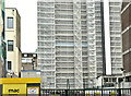
7
River House, Belfast (July 2014)
The relatively-modest (by international standards) 15 floors of River House dominate the flat reclaimed land between High Street and Donegall Quay. This view is from the Laganside Walkway, near the Albert Bridge. The Lagan railway bridge Image is at the bottom.
Image: © Albert Bridge
Taken: 24 Jul 2014
0.01 miles
8
River House, Belfast - July 2017(1)
The High Street side (front) of the building, entirely covered by plastic sheeting.
Image: © Albert Bridge
Taken: 10 Jul 2017
0.01 miles
9
River House, Belfast - October 2017(2)
Renovation of the ground floor continuing on the High Street side.
Image: © Albert Bridge
Taken: 28 Oct 2017
0.01 miles
10
River House, Belfast - July 2017(2)
The back of the building, entirely covered by plastic sheeting, seen from Waring Street.
Image: © Albert Bridge
Taken: 10 Jul 2017
0.01 miles