IMAGES TAKEN NEAR TO
Ebor Street, BELFAST, BT12 6NN
Introduction
This page details the photographs taken nearby to Ebor Street, BT12 6NN by members of the Geograph project.
The Geograph project started in 2005 with the aim of publishing, organising and preserving representative images for every square kilometre of Great Britain, Ireland and the Isle of Man.

There are currently over 7.5m images from over14,400 individuals and you can help contribute to the project by visiting https://www.geograph.org.uk
Image Map
Images are licensed for reuse under creativecommons.org/licenses/by-sa/2.0
Notes
- Clicking on the map will re-center to the selected point.
- The higher the marker number, the further away the image location is from the centre of the postcode.
Image Listing (239 Images Found)
Images are licensed for reuse under creativecommons.org/licenses/by-sa/2.0
Image
Details
Distance
1
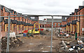
Ebor Street, Belfast (2013)
The view from Frenchpark Street showing the new Ebor Street under construction (on the same line as its predecessor).
Image: © Albert Bridge
Taken: 21 Apr 2013
0.03 miles
2
Moltke Street, Belfast (2013-1)
The western side of Moltke Street, between Frenchpark Street and Broadway, where five houses are still standing.
Image: © Albert Bridge
Taken: 21 Apr 2013
0.03 miles
3
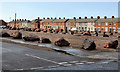
Broadway Parade and Moltke Street, Belfast
The houses between the southern side of Broadway Image (foreground), the western side of Broadway Parade Image and the eastern side of Moltke Street have been demolished. The trace of the former entry between the latter can be seen above the boulders. The houses (background) were replaced by these Image
Image: © Albert Bridge
Taken: 10 Nov 2011
0.04 miles
4
Moltke Street, Belfast (2013-2)
The eastern side of Moltke Street with a row of houses awaiting demolition. Broadway Parade is on the right.
Image: © Albert Bridge
Taken: 21 Apr 2013
0.04 miles
5
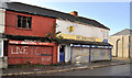
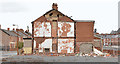
Closed shops, Belfast
Closed and blocked-up shops, on the southern side of Broadway Image, at the corner of Ebor Street.
Image: © Albert Bridge
Taken: 10 Nov 2011
0.04 miles
6
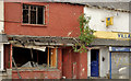
Derelict shops, Belfast (3)
Derelict shops, at the corner of Ebor Street and Broadway, awaiting demolition. Vandalised since last seen in November 2011 Image
Image: © Albert Bridge
Taken: 23 May 2012
0.04 miles
7
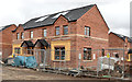
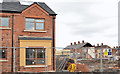
New houses, Frenchpark Street, Belfast (2013-1)
New apartments under construction at the corner of Frenchpark Street and Ebor Street (right).
Image: © Albert Bridge
Taken: 21 Apr 2013
0.04 miles
8
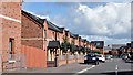
Moltke Street, Belfast (August 2015)
The redeveloped western side of Moltke Street seen from Frenchpark Street. The houses on the left replaced those in the background Image (November 2011).
Image: © Albert Bridge
Taken: 15 Aug 2015
0.04 miles
9
New houses, Frenchpark Street, Belfast (2013-2)
New apartments under construction, in Frenchpark Street, close the remains of Moltke Street and Broadway Parade (right).
Image: © Albert Bridge
Taken: 21 Apr 2013
0.05 miles
10
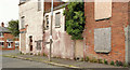
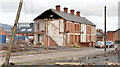
Kilburn Street corner, Belfast
Kilburn Street runs from Moltke Street to Frenchpark Street. This derelict house and shop are at the western corner of the latter. Kilburn Street had been laid out by 1901 but, by the end of WW1, it had only nine houses. Nos 1-95 had still to be built. Most of the houses remain occupied. This dereliction is an exception.
Image: © Albert Bridge
Taken: 23 May 2012
0.05 miles