IMAGES TAKEN NEAR TO
Broadway Parade, BELFAST, BT12 6JX
Introduction
This page details the photographs taken nearby to Broadway Parade, BT12 6JX by members of the Geograph project.
The Geograph project started in 2005 with the aim of publishing, organising and preserving representative images for every square kilometre of Great Britain, Ireland and the Isle of Man.

There are currently over 7.5m images from over14,400 individuals and you can help contribute to the project by visiting https://www.geograph.org.uk
Image Map
Images are licensed for reuse under creativecommons.org/licenses/by-sa/2.0
Notes
- Clicking on the map will re-center to the selected point.
- The higher the marker number, the further away the image location is from the centre of the postcode.
Image Listing (216 Images Found)
Images are licensed for reuse under creativecommons.org/licenses/by-sa/2.0
Image
Details
Distance
1
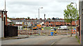
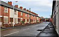
The Village redevelopment, Belfast (May 2014)
The site, close to Broadway and Moltke Street, seen along Nubia Street. There is a crane (middle left) awaiting assembly.
Image: © Albert Bridge
Taken: 8 May 2014
0.02 miles
2
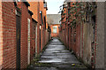
Back entry, Belfast (5)
A back entry, on the northern side of Broadway Image, between Broadway Parade Image(left) and Soudan Street Image It can be seen to the right of the mural in Image
Image: © Albert Bridge
Taken: 10 Nov 2011
0.02 miles
3
New houses, The Village, Belfast - December 2014(1)
New houses, under construction, on what (I think) was the site of Soudan Street Image (November 2011).
Image: © Albert Bridge
Taken: 4 Dec 2014
0.02 miles
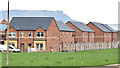
4
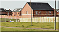
New houses, The Village, Belfast - February 2015(1)
Redevelopment of The Village continuing along Kitchener Drive (Kitchener Street on the Google map), between Soudan Street and Broadway Parade. For reference purposes Kitchener Street is at bottom right.
Image: © Albert Bridge
Taken: 23 Feb 2015
0.03 miles
5
Moltke Street, Belfast (1)
See Image Vacant and blocked-up houses in that part of Moltke Street (western side), to the north of Broadway Image, looking towards Kitchener Drive. Continue to Image
Image: © Albert Bridge
Taken: 10 Nov 2011
0.03 miles
6
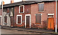
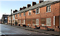
Moltke Street, Belfast (3)
See Image Vacant and blocked-up houses (probably dating from the very late 19th century) on the eastern side of the northern end of Moltke Street.
Image: © Albert Bridge
Taken: 10 Nov 2011
0.03 miles
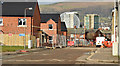
7
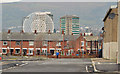
Kitchener Drive, Belfast - January 2014
The view, west, along Kitchener Drive (Kitchener Street on the Google map) towards Ebor Street. With one small exception all the streets on the south (left) have been demolished. “The Rise” sculpture http://www.geograph.org.uk/snippet/5211 and Broadway Towers Image are in the background.
Image: © Albert Bridge
Taken: 30 Jan 2014
0.03 miles
8
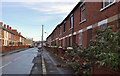
Soudan Street, Belfast (2)
See Image The other side of the street, from close to Broadway Image, looking towards Kitchener Drive (background).
Image: © Albert Bridge
Taken: 10 Nov 2011
0.03 miles
9
New houses, The Village, Belfast - February 2015(2)
New houses under construction between Soudan Street and Broadway Parade. For reference purposes Kitchener Street is at the bottom.
Image: © Albert Bridge
Taken: 23 Feb 2015
0.03 miles
10
Moltke Street, Belfast (2)
Image: © Albert Bridge
Taken: 10 Nov 2011
0.04 miles