IMAGES TAKEN NEAR TO
Benburb Street, BELFAST, BT12 6JJ
Introduction
This page details the photographs taken nearby to Benburb Street, BT12 6JJ by members of the Geograph project.
The Geograph project started in 2005 with the aim of publishing, organising and preserving representative images for every square kilometre of Great Britain, Ireland and the Isle of Man.

There are currently over 7.5m images from over14,400 individuals and you can help contribute to the project by visiting https://www.geograph.org.uk
Image Map
Images are licensed for reuse under creativecommons.org/licenses/by-sa/2.0
Notes
- Clicking on the map will re-center to the selected point.
- The higher the marker number, the further away the image location is from the centre of the postcode.
Image Listing (239 Images Found)
Images are licensed for reuse under creativecommons.org/licenses/by-sa/2.0
Image
Details
Distance
1
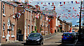
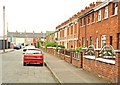
Benburb Street, Belfast (1)
Benburb Street runs from Tate’s Avenue to the Donegall Road. The street was built towards the end of the 19th century but has since been partly redeveloped. Ruby Murray’s former home (odds side – left) no longer exists. Image shows the Donegall Road end of the street in April 2012.
Image: © Albert Bridge
Taken: 10 Aug 2010
0.01 miles
2
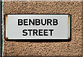
Benburb Street, Belfast (2)
The name sign at the Tate’s Avenue end (western side).
Image: © Albert Bridge
Taken: 10 Aug 2010
0.02 miles
3
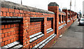
Tate's Avenue, Belfast (4)
See Image The southern side of the retaining wall, at the Glenmachan Street end of Tate’s Avenue.
Image: © Albert Bridge
Taken: 10 Aug 2010
0.03 miles
4
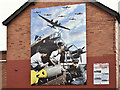
Polish Air Forces (Polskie Siły Powietrzne) mural, Benburb Street, Belfast ? August 2016(1)
A mural, at the Frenchpark Street end of Benburb Street Image, marking the contribution made by Polish airmen during WWII. The plaque (lower right) records that many Polish servicemen remained in Great Britain and Ireland after the war. See also Image For more information see https://en.wikipedia.org/wiki/Polish_Air_Forces_in_France_and_Great_Britain. Image is a detail from the mural showing the Polish inscription on a bomb.
Image: © Albert Bridge
Taken: 5 Aug 2016
0.04 miles
5

Polish Air Forces (Polskie Siły Powietrzne) mural, Benburb Street, Belfast ? August 2016(2)
See Image A detail from the mural showing the Polish inscription on a bomb.
Image: © Albert Bridge
Taken: 5 Aug 2016
0.04 miles
6
Olympia Parade, Belfast
Part of “The Village” off Tate’s Avenue (background) and close to Windsor Park football ground (out of picture behind me to the right). The streets here were built on strict geometrical lines.
Image: © Albert Bridge
Taken: 12 Aug 2009
0.04 miles
7
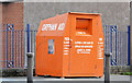
Clothing bank, Belfast (2)
A bin for unwanted clothing at the Tate’s Avenue end of Lecale Street.
Image: © Albert Bridge
Taken: 21 Apr 2013
0.05 miles
8
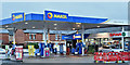
Maxol and Spar, Tate's Avenue, Belfast (December 2017)
Maxol petrol station and Spar shop at the corner of Olympia Parade. I have no connection with the business.
Image: © Albert Bridge
Taken: 17 Dec 2017
0.05 miles
9
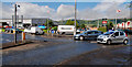
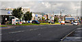
Tate's Avenue roundabout, Belfast
A small roundabout, at the junction of Tate’s Avenue Image (foreground), the Boucher Road Image (left) and Glenmachan Street Image right. Part of a shortcut from the Lisburn Road to the M1. At certain times it competes with the dodgems for thrills.
Image: © Albert Bridge
Taken: 10 Aug 2010
0.06 miles
10
The Boucher Road, Belfast
A long road, of about 1½ miles, running from Stockman’s Lane Image to Tate’s Avenue roundabout Image (middle right). An “infill” development between the M1 and the railway, it (and the various side roads) is home to numerous wholesalers, retail warehouses, car showrooms and might have more retail floor space than the rest of Belfast combined.
Image: © Albert Bridge
Taken: 10 Aug 2010
0.06 miles