IMAGES TAKEN NEAR TO
Boucher Crescent, BELFAST, BT12 6HU
Introduction
This page details the photographs taken nearby to Boucher Crescent, BT12 6HU by members of the Geograph project.
The Geograph project started in 2005 with the aim of publishing, organising and preserving representative images for every square kilometre of Great Britain, Ireland and the Isle of Man.

There are currently over 7.5m images from over14,400 individuals and you can help contribute to the project by visiting https://www.geograph.org.uk
Image Map
Images are licensed for reuse under creativecommons.org/licenses/by-sa/2.0
Notes
- Clicking on the map will re-center to the selected point.
- The higher the marker number, the further away the image location is from the centre of the postcode.
Image Listing (8 Images Found)
Images are licensed for reuse under creativecommons.org/licenses/by-sa/2.0
Image
Details
Distance
1
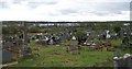
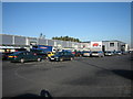
View across the eastern end of Milltown Cemetery in the direction of M1 and the Boucher Shopping Centre
Image: © Eric Jones
Taken: 27 Apr 2012
0.08 miles

5
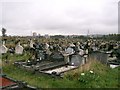
Milltown Cemetery
This cemetery has been the burial place for the Catholic people of Belfast for many years.
Image: © Paul McIlroy
Taken: 21 Oct 2005
0.24 miles
7

The Bog Meadows
This nature reserve is located between the M1 motorway and the top of the Falls Road. This is an ancient marsh of about 20 hectares, a fragment of what was once a much larger wetland. It is famous as being the place in Belfast where the increasingly rare corncrake was last heard in the early 1990s. Its preservation has in large part been due to the efforts of a local pressure group 'The Friends of Bog Meadows', formed in 1989. It contains traditionally grazed meadows, open pond areas and woodland scrub and is now managed by the Ulster Wildlife Trust. Belfast City Council designated the site as a Local Nature Reserve, one of only three such sites in Northern Ireland.
Image: © Paul McIlroy
Taken: 18 May 2007
0.24 miles
8
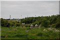
The Bog Meadows
Looking southwest where the floodlights of Casement Park are evident, they appear to be taller than the lights at other sports grounds.Image
Image: © Paul McIlroy
Taken: 18 May 2007
0.24 miles