IMAGES TAKEN NEAR TO
Maldon Court, BELFAST, BT12 6GY
Introduction
This page details the photographs taken nearby to Maldon Court, BT12 6GY by members of the Geograph project.
The Geograph project started in 2005 with the aim of publishing, organising and preserving representative images for every square kilometre of Great Britain, Ireland and the Isle of Man.

There are currently over 7.5m images from over14,400 individuals and you can help contribute to the project by visiting https://www.geograph.org.uk
Image Map
Images are licensed for reuse under creativecommons.org/licenses/by-sa/2.0
Notes
- Clicking on the map will re-center to the selected point.
- The higher the marker number, the further away the image location is from the centre of the postcode.
Image Listing (112 Images Found)
Images are licensed for reuse under creativecommons.org/licenses/by-sa/2.0
Image
Details
Distance
1
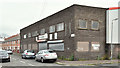
Nos 27-29 Rydalmere Street, Belfast (June 2016)
Former vehicle body repair shop at the corner of Lemberg Street (right).
Image: © Albert Bridge
Taken: 7 Jun 2016
0.05 miles
2
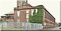
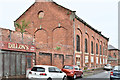
Former Ulidia factory, Belfast - June 2016(1)
See Image The clothing and textile factories in Belfast are now but a memory. Many have been demolished and redeveloped. The Ulidia is a surprising survivor – vacant but otherwise apparently intact. To the best of my knowledge there are no immediate proposals for redevelopment, conversion or any alternative use. This is the Rydalmere Street side. Image shows the Empire Street side.
Image: © Albert Bridge
Taken: 7 Jun 2016
0.07 miles
3
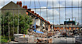
Lower Rockview Street, Belfast (1)
A major demolition underway in Lower Rockview Street (looking towards Monarch Parade), off the Donegall Road. The street seems to have been built towards the end of the 19th century. The following is an extract from an official press release: “The Minister helped demolish the first 40 houses included in the redevelopment area, which will allow for the first phase of 36 new homes to be built later this year.
Speaking in Lower Rockview Street, Donegall Road, Minister [Nelson] McCausland said: "Through its very name the Village has been an important community area in Belfast for many years. Unfortunately, the worsening housing conditions over those years led to the declaration of the Village as a redevelopment area. We are now seeing the start of the regeneration of this proud area through demolition of unfit housing to make way for new homes built to very high standards . . . . . . The Minister concluded: "The first phase involving the construction of 36 new homes will get underway later this year and will be an important milestone in the journey towards a new Village."” Image shows the street after rebuilding.
Image: © Albert Bridge
Taken: 12 Jun 2011
0.09 miles
4
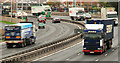
The Westlink, Belfast (8)
See Image The section of the Westlink (looking towards the M1) between Roden Street Image and Broadway. The countdown marker for the Broadway off-slip Image can be seen above the lorry on the left. Continue to Image
Image: © Albert Bridge
Taken: 18 Nov 2009
0.10 miles
5
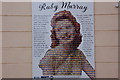
Ruby Murray plaque, Belfast
This (self-explanatory) tribute to the late Ruby Murray is in Maldon Street on the Donegall Road, Belfast. See also Image
Image: © Albert Bridge
Taken: 18 Feb 2007
0.11 miles
6
Former Ulidia factory, Belfast - June 2016(2)
See Image The Empire Street side.
Image: © Albert Bridge
Taken: 7 Jun 2016
0.11 miles
7
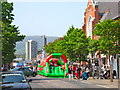
Royal Wedding celebrations, Donegall Road, Belfast
This event, which closed the busy thoroughfare from Rockview Street to Donegall Avenue, was one of several similar events taking place across the city to celebrate the marriage of Prince William, the Duke of Cambridge and Kate Middleton on April 29, 2011. The ceremony was still underway when the photograph was taken, which perhaps explains why the crowd was not big.
Image: © Dean Molyneaux
Taken: 29 Apr 2011
0.12 miles
8
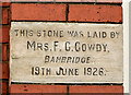
Foundation stone, Donegall Road Methodist church, Belfast
There are several foundation stones on Donegall Road Methodist church Image This one was laid by Mrs FC Cowdy of Banbridge Image on 19 June 1926. For anyone curious about the origin and history of foundation stones this Wiki link http://en.wikipedia.org/wiki/Foundation_stone makes interesting reading.
Image: © Albert Bridge
Taken: 8 Feb 2014
0.12 miles
9
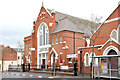
Donegall Road Methodist church, Belfast
The present Donegall Road Methodist church, at the corner of Maldon Street, opened in 1927 replacing a much smaller one built in 1902. There was another Methodist church nearby, at the corner of Primitive Street, which was demolished as part of the redevelopment of the area around Sandy Row. The church hall (right) has a date stone showing 1937. See also Image
Image: © Albert Bridge
Taken: 8 Feb 2014
0.12 miles
10
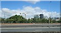
Construction work at the Royal Belfast Hospital for Sick Children
The image was taken across the Westlink.
Image: © Eric Jones
Taken: 21 Jun 2019
0.12 miles