IMAGES TAKEN NEAR TO
St. Katharines Road, BELFAST, BT12 6EF
Introduction
This page details the photographs taken nearby to St. Katharines Road, BT12 6EF by members of the Geograph project.
The Geograph project started in 2005 with the aim of publishing, organising and preserving representative images for every square kilometre of Great Britain, Ireland and the Isle of Man.

There are currently over 7.5m images from over14,400 individuals and you can help contribute to the project by visiting https://www.geograph.org.uk
Image Map
Images are licensed for reuse under creativecommons.org/licenses/by-sa/2.0
Notes
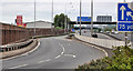
- Clicking on the map will re-center to the selected point.
- The higher the marker number, the further away the image location is from the centre of the postcode.
Image Listing (50 Images Found)
Images are licensed for reuse under creativecommons.org/licenses/by-sa/2.0
Image
Details
Distance
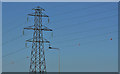
1
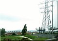
Pylon alongside the M1
The houses beyond are on St Katherine's and St James' Road off the Falls Road.
Image: © Eric Jones
Taken: 4 Jun 2016
0.10 miles
2
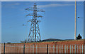
Pylon and power lines, south west Belfast (1)
The pylon, in the Bog Meadows close to the M1, is the first sign of the overhead lines carrying the grid towards Black’s Road and Dunmurry. The view is from Glenmachan Place Image Image shows the next pylon.
Image: © Albert Bridge
Taken: 3 Jul 2011
0.10 miles
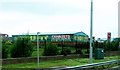
4
Trufit Exhausts
This is located between Rodney Place and the M1
Image: © Eric Jones
Taken: 21 Jun 2019
0.12 miles
5
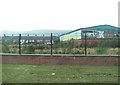
Pylon and power lines, south west Belfast (2)
See Image This is the next pylon to the south west. They continue, parallel to the motorway as far as the Stockman’s Lane roundabout and are a prominent feature when approaching Belfast along the M1. The view is from Glenmachan Place Image The grid continues towards Image
Image: © Albert Bridge
Taken: 3 Jul 2011
0.12 miles
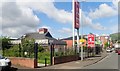
6
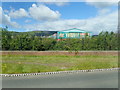
G T Trufit Exhausts, Donegall Road, Belfast
The image was taken from the A12 (M1).
Image: © Eric Jones
Taken: 4 Jun 2016
0.12 miles
8
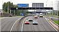
The Broadway underpass, Belfast (2)
The view, along the M1, towards Lisburn and Dungannon, from the top of the underpass. There is a variable speed limit Image here. The sign is showing “national speed limit applies” early on a Sunday morning.
Image: © Albert Bridge
Taken: 19 Jun 2011
0.13 miles
9
The M1, Belfast (2)
The view along what is now the south/westbound on-slip. Before the rebuilding of the Westlink Image and the construction of the Broadway underpass Image this was the start of the M1. It now starts a short distance to the north east Image
Image: © Albert Bridge
Taken: 19 Jun 2011
0.14 miles
10
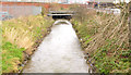
The Blackstaff River, Belfast - February 2014
The Blackstaff River, higher than usual after the prolonged rain during January and February, looking downstream at Glenmachan Place. For a contrasting summer view see Image in June 2011.
Image: © Albert Bridge
Taken: 8 Feb 2014
0.15 miles