IMAGES TAKEN NEAR TO
Falls Road, BELFAST, BT12 6AA
Introduction
This page details the photographs taken nearby to Falls Road, BT12 6AA by members of the Geograph project.
The Geograph project started in 2005 with the aim of publishing, organising and preserving representative images for every square kilometre of Great Britain, Ireland and the Isle of Man.

There are currently over 7.5m images from over14,400 individuals and you can help contribute to the project by visiting https://www.geograph.org.uk
Image Map
Images are licensed for reuse under creativecommons.org/licenses/by-sa/2.0
Notes
- Clicking on the map will re-center to the selected point.
- The higher the marker number, the further away the image location is from the centre of the postcode.
Image Listing (43 Images Found)
Images are licensed for reuse under creativecommons.org/licenses/by-sa/2.0
Image
Details
Distance
1
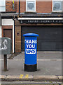
Pillar box, Belfast
George VI postbox (BT12 1250) on the Falls Road in Belfast. It has been painted blue as a tribute to NHS workers during the Coronavirus pandemic. See also Image
Image: © Rossographer
Taken: 6 Jun 2020
0.01 miles
2
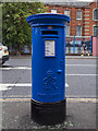
Pillar box, Belfast
George VI postbox (BT12 1250) on the Falls Road in Belfast. It has been painted blue as a tribute to NHS workers during the Coronavirus pandemic. The Royal Victoria Hospital is behind. See also Image
Image: © Rossographer
Taken: 6 Jun 2020
0.01 miles
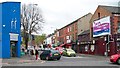
3
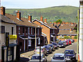
Falls Pharmacy and Falls Family Doctors Surgery on the Falls Road
This block stands on the corner of the Falls and Springfield roads.
Image: © Eric Jones
Taken: 27 Apr 2012
0.01 miles
4
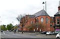
St Paul's Catholic Church in the mid-Falls area
This church stands adjacent to a girls' grammar school and a university college and opposite the Royal Victoria - one of Ireland's leading hospitals. These are images which are at odds with the average Brit's impression of the Falls Road as a place of terraced housing, street riots and mayhem.
Image: © Eric Jones
Taken: 27 Apr 2012
0.01 miles
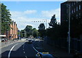
5
The lower end of Springfield Road viewed from the Falls Road
Like The Falls, the Springfield area is strongly nationalist and republican. It borders on to the equally staunch Protestant and Loyalist area of the Shankill.
http://en.wikipedia.org/wiki/Springfield_Road,_Belfast
Image: © Eric Jones
Taken: 27 Apr 2012
0.02 miles
7
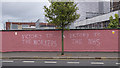
Graffiti, Belfast
Graffiti on a wall at the Royal Victoria Hospital, Falls Road, Belfast. It appeared during the Coronavirus pandemic.
Image: © Rossographer
Taken: 6 Jun 2020
0.03 miles
8
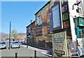
Belfast, mural 1)
On the corner of McQuillan Street and Falls Road; dedicated to freedom fighters.
Image: © Mike Faherty
Taken: 21 Apr 2018
0.04 miles
9
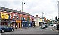
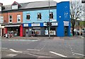
A row of small shops on the Falls Road
This image is taken from the corner of Grosvenor Road.
Image: © Eric Jones
Taken: 27 Apr 2012
0.04 miles