IMAGES TAKEN NEAR TO
Abingdon Drive, BELFAST, BT12 5PX
Introduction
This page details the photographs taken nearby to Abingdon Drive, BT12 5PX by members of the Geograph project.
The Geograph project started in 2005 with the aim of publishing, organising and preserving representative images for every square kilometre of Great Britain, Ireland and the Isle of Man.

There are currently over 7.5m images from over14,400 individuals and you can help contribute to the project by visiting https://www.geograph.org.uk
Image Map
Images are licensed for reuse under creativecommons.org/licenses/by-sa/2.0
Notes
- Clicking on the map will re-center to the selected point.
- The higher the marker number, the further away the image location is from the centre of the postcode.
Image Listing (106 Images Found)
Images are licensed for reuse under creativecommons.org/licenses/by-sa/2.0
Image
Details
Distance
1
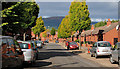
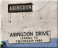
Abingdon Drive, Belfast (1)
Abingdon Drive runs from the Donegall Road to Barrington Gardens (background). Built on the line of Abingdon Street, a late 19th century street, which ran to Barrington Street. Abingdon Street (of which there is now no trace) was the birthplace of Alex Higgins.
Image: © Albert Bridge
Taken: 24 Sep 2010
0.01 miles
2
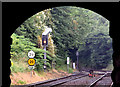
City Jct, Belfast (July 2014)
City Jct (no public access) is where the line to Gt Victoria Street diverges (right) from the Belfast Central line. It opened in 1995 Image as part of the restoration of the line between Central Jct and Gt Victoria Street (closed in 1976) and allows trains to/from the Bangor direction to serve Gt Victoria Street without a reversal at Central Jct. This view is from City Hospital station with the road set for the 08.58 Bangor – Portadown Image
Image: © Albert Bridge
Taken: 27 Jul 2014
0.01 miles
3
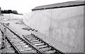
City Jct, Belfast (1995)
The view from the 08.25 Belfast Central – Portrush (via Lisburn) showing City Jct before the re-opening of Gt Victoria Street station Image The turnouts had been installed but the track had still to be laid.
Image: © Albert Bridge
Taken: 5 Aug 1995
0.02 miles
4
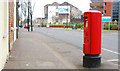
Pillar box, Belfast
EIIR pillar box on the Donegall Road, close to Colchester Park. The Google map continues to use the spelling “Donegal” (the county) rather than the correct version “Donegall” (after the Marquis upon whose land Belfast was built).
Image: © Albert Bridge
Taken: 30 Jan 2011
0.06 miles
5
Abingdon Drive, Belfast (2)
See Image The signs at the Donegall Road end. The tiled Abingdon Street sign has survived but with the word “Street” removed.
Image: © Albert Bridge
Taken: 24 Sep 2010
0.06 miles
6
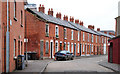
Fortuna Street, Belfast
A street of late 19th century terrace houses off the Donegall Road. The Google map continues to use the spelling “Donegal” (the county) rather than the correct version “Donegall” (after the Marquis upon whose land Belfast was built).
Image: © Albert Bridge
Taken: 30 Jan 2011
0.06 miles
7
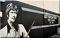
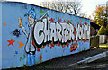
Alex Higgins mural, Belfast
Alex Higgins mural, on a wall in Abingdon Drive, off the Donegall Road, close to the place of his birth.
Image: © Albert Bridge
Taken: 24 Sep 2010
0.07 miles
8
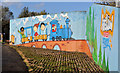
Blythefield mural, Belfast (1)
A mural on the eastern side of the railway footbridge at Bentham Drive. The footbridge crosses the Blythefield curve which carries trains between Gt Victoria Street and Botanic/Central. Image shows the mural on the western side of the same bridge.
Image: © Albert Bridge
Taken: 10 Nov 2011
0.08 miles
9
Blythefield mural, Belfast (2)
See Image The mural on the western side of the same bridge.
Image: © Albert Bridge
Taken: 10 Nov 2011
0.08 miles
10
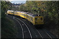
GVS Avoiding Curve
NIR's 80 Class Sandite train rounds the GVS Avoiding Curve with the daytime sandite.
Image: © N-a
Taken: 29 Oct 2014
0.10 miles