IMAGES TAKEN NEAR TO
Linfield Drive, BELFAST, BT12 5DD
Introduction
This page details the photographs taken nearby to Linfield Drive, BT12 5DD by members of the Geograph project.
The Geograph project started in 2005 with the aim of publishing, organising and preserving representative images for every square kilometre of Great Britain, Ireland and the Isle of Man.

There are currently over 7.5m images from over14,400 individuals and you can help contribute to the project by visiting https://www.geograph.org.uk
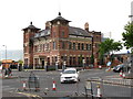
Image Map
Images are licensed for reuse under creativecommons.org/licenses/by-sa/2.0
Notes
- Clicking on the map will re-center to the selected point.
- The higher the marker number, the further away the image location is from the centre of the postcode.
Image Listing (1398 Images Found)
Images are licensed for reuse under creativecommons.org/licenses/by-sa/2.0
Image
Details
Distance
1
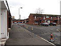
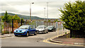
New housing in Kenmaree Park and Linfield Drive off Sandy Row
Huge tracks of Victorian and Edwardian terraced housing in inner Belfast were replaced after the Peace Agreenment by new and pleasanter housing estates.
Image: © Eric Jones
Taken: 17 Feb 2015
0.01 miles
2

Children's mural, Belfast
I’m guessing that this mural, on a wall on the Linfield Road, was painted (or inspired) by a local school. If anyone has the full story let me know so that I may change the caption.
Image: © Albert Bridge
Taken: 18 Jun 2010
0.02 miles
4
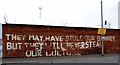
Message on the Wall of the Belfast Ice Dome
This graffiti is in Linfield Gardens on the edge of the staunchly Loyalist Sandy Row area. It refers to the decision of the Belfast City Council to restrict the flying of the Union Flag over Belfast City Hall to a number of designated days each year.
Image: © Eric Jones
Taken: 17 Feb 2015
0.03 miles
5
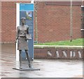
Mother Daughter Sister Sculpture in Sandy Row
This piece of street art, one of a series of such sculptures celebrating Belfast women by the artist Ross Wilson, was unveiled on Friday 12th June 2015.
http://www.artscouncil-ni.org/news/new-artwork-celebrates-the-women-of-sandy-row
Image: © Eric Jones
Taken: 28 Mar 2017
0.03 miles
6
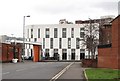
Modern extensions to the former Murray's Tobacco Works
This former factory has been converted into prestige offices.
Image: © Eric Jones
Taken: 17 Feb 2015
0.03 miles
7
Watson Street, Belfast
Watson Street (“Vulcan Street” on the Google map) dates from about 1877/79. It ran from the Linfield Road to Railway Street and had “a number of small houses”. Now gone and just a line.
Image: © Albert Bridge
Taken: 18 Jun 2010
0.04 miles
8
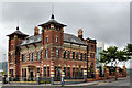
Murray's Exchange, Belfast (5)
See Image The completed building seen from Sandy Row. This one (September 2005) Image shows the building before the modernisation. The changes include the removal of the rearward extension (also seen in Image) and the removal of the extended porch.
Image: © Albert Bridge
Taken: 19 Jun 2011
0.04 miles
9
The former Murray's Whitehall (Erinmore) tobacco factory,
This is located in Linfield Gardens. It has been redeveloped as a prestigious office building.
Image: © Eric Jones
Taken: 17 Feb 2015
0.04 miles
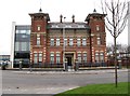
10
The former Whitehall Tobacco Works in Linfield Road
This is one of a number of sources of employment for the Protestant working class community of the Sandy Row area which has disappeared during the past three or four decades. This decline has caused chronic unemployment problems in the area.
Image: © Eric Jones
Taken: 20 May 2012
0.04 miles