1
New housing in Kenmaree Park and Linfield Drive off Sandy Row
Huge tracks of Victorian and Edwardian terraced housing in inner Belfast were replaced after the Peace Agreenment by new and pleasanter housing estates.
Image: © Eric Jones
Taken: 17 Feb 2015
0.02 miles
2
Houses in Linfield Gardens
Image: © Eric Jones
Taken: 17 Feb 2015
0.03 miles
3
Children's mural, Belfast
I’m guessing that this mural, on a wall on the Linfield Road, was painted (or inspired) by a local school. If anyone has the full story let me know so that I may change the caption.
Image: © Albert Bridge
Taken: 18 Jun 2010
0.03 miles
4
Message on the Wall of the Belfast Ice Dome
This graffiti is in Linfield Gardens on the edge of the staunchly Loyalist Sandy Row area. It refers to the decision of the Belfast City Council to restrict the flying of the Union Flag over Belfast City Hall to a number of designated days each year.
Image: © Eric Jones
Taken: 17 Feb 2015
0.03 miles
5
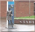
Mother Daughter Sister Sculpture in Sandy Row
This piece of street art, one of a series of such sculptures celebrating Belfast women by the artist Ross Wilson, was unveiled on Friday 12th June 2015.
http://www.artscouncil-ni.org/news/new-artwork-celebrates-the-women-of-sandy-row
Image: © Eric Jones
Taken: 28 Mar 2017
0.04 miles
6
Whitehall Tobacco Works
As seen from Boyne Bridge
Image: © Kenneth Allen
Taken: 10 Jun 2007
0.04 miles
7
McAdam Park Methodist Church in Sandy Row
Image: © Eric Jones
Taken: 19 May 2012
0.04 miles
8
Modern extensions to the former Murray's Tobacco Works
This former factory has been converted into prestige offices.
Image: © Eric Jones
Taken: 17 Feb 2015
0.04 miles
9
Watson Street, Belfast
Watson Street (“Vulcan Street” on the Google map) dates from about 1877/79. It ran from the Linfield Road to Railway Street and had “a number of small houses”. Now gone and just a line.
Image: © Albert Bridge
Taken: 18 Jun 2010
0.04 miles
10
Loyalist mural, Belfast
One of the most infamous murals in central Belfast, this UFF http://en.wikipedia.org/wiki/Ulster_Freedom_Fighters mural was located on a gable wall at the northern end of Sandy Row in the city. When this was taken, on Friday 22nd June 2012, preparations were being made for its removal; on Monday 24th June it was completely painted over http://www.bbc.co.uk/news/uk-northern-ireland-18578998 . It will be replaced with a portrait of William of Orange.
Image: © Rossographer
Taken: 22 Jun 2012
0.05 miles


