IMAGES TAKEN NEAR TO
Divis Street, BELFAST, BT12 4AL
Introduction
This page details the photographs taken nearby to Divis Street, BT12 4AL by members of the Geograph project.
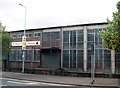
The Geograph project started in 2005 with the aim of publishing, organising and preserving representative images for every square kilometre of Great Britain, Ireland and the Isle of Man.

There are currently over 7.5m images from over14,400 individuals and you can help contribute to the project by visiting https://www.geograph.org.uk
Image Map
Images are licensed for reuse under creativecommons.org/licenses/by-sa/2.0
Notes
- Clicking on the map will re-center to the selected point.
- The higher the marker number, the further away the image location is from the centre of the postcode.
Image Listing (577 Images Found)
Images are licensed for reuse under creativecommons.org/licenses/by-sa/2.0
Image
Details
Distance
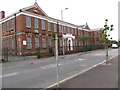
1
St Mary's Primary School, Divis Street
This stands between Barracks Street and the Westlink.
Image: © Eric Jones
Taken: 9 Aug 2011
0.01 miles
2
St Mary's Primary School, Barrack Street
This school over looks the Westlink. The Divis Tower on the other side of the Westlink forms the prominent feature in the background.
.
Image: © Eric Jones
Taken: 20 May 2012
0.01 miles
3
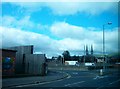
Slip road linking Divis Street with the south-bound carriageway of the Westlink
The spires of St Peter's Cathedral can be seen in the background.
Image: © Eric Jones
Taken: 9 Aug 2011
0.02 miles
4
Westcourt Centre in Barrack Street
Westcourt, based in the former Christian Brothers School at Barrack Street, provides "educational programmes aimed at young people who have rejected or been excluded from school, and also provides a valuable community resource for youth and multi-ethnic work".
http://www.northernireland.gov.uk/index/media-centre/news-departments/news-dsd/news-dsd-april-2008/news-dsd-100408-minister-ritchie-launches.htm
Image: © Eric Jones
Taken: 20 May 2012
0.03 miles
5
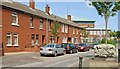
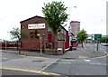
Barrack Street, Belfast
Barrack Street has been in existence for more than 200 years but, unlike its neighbour Galway Street Image, the original houses have not survived. Today’s street still follows the same line. The name seems to come from an army barracks built in 1737 in nearby Mill Street (now part of Castle Street Image).
Image: © Albert Bridge
Taken: 27 Jul 2009
0.03 miles
6
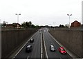
The Westlink from the Divis Street road bridge
Image: © Eric Jones
Taken: 20 May 2012
0.04 miles
7
The Westlink, Belfast (12)
Image: © Albert Bridge
Taken: 19 Feb 2010
0.04 miles
8
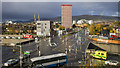
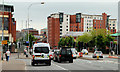
Divis Street, Belfast
The busy road junction of the Westlink and Divis Street in Belfast. Divis Tower is behind with Black Mountain and Divis Mountain itself in the background.
Image: © Rossographer
Taken: 26 Oct 2018
0.04 miles
9
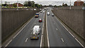
The Westlink, Belfast
Looking south on the Westlink from Divis Street in Belfast. Taken at 12:30pm with fairly light and free-flowing traffic.
Image: © Rossographer
Taken: 10 Sep 2019
0.04 miles
10
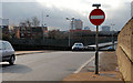
Divis Street traffic lights, Belfast
Traffic lights controlling the various permutations of traffic between Divis Street and the Westlink Image
Image: © Albert Bridge
Taken: 18 Jun 2010
0.04 miles