IMAGES TAKEN NEAR TO
North Street, BELFAST, BT1 1LD
Introduction
This page details the photographs taken nearby to North Street, BT1 1LD by members of the Geograph project.
The Geograph project started in 2005 with the aim of publishing, organising and preserving representative images for every square kilometre of Great Britain, Ireland and the Isle of Man.

There are currently over 7.5m images from over14,400 individuals and you can help contribute to the project by visiting https://www.geograph.org.uk
Image Map
Images are licensed for reuse under creativecommons.org/licenses/by-sa/2.0
Notes
- Clicking on the map will re-center to the selected point.
- The higher the marker number, the further away the image location is from the centre of the postcode.
Image Listing (2972 Images Found)
Images are licensed for reuse under creativecommons.org/licenses/by-sa/2.0
Image
Details
Distance
1
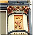
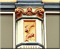
Decorated columns, Belfast (3)
See Image This one seems to have a fold of cloth, in the shape of a bell, over a solitary leaping fish.
Image: © Albert Bridge
Taken: 19 Apr 2009
0.01 miles
2
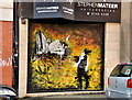
Decorated shutter door, Belfast
A decorated shutter door at a hairdresser in (lower) North Street.
Image: © Albert Bridge
Taken: 30 Sep 2012
0.01 miles
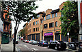
3
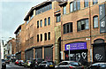
Temple Court, Belfast - December 2017(1)
The North Street side of an office building currently proposed for demolition.
Image: © Albert Bridge
Taken: 3 Dec 2017
0.01 miles
4
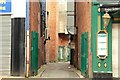
Entry, Belfast (1)
An unnamed entry running off the north western side of Lower Garfield Street Image Continue to Image
Image: © Albert Bridge
Taken: 19 Apr 2009
0.01 miles
5
Temple Court, Belfast (1)
An office building, in lower North Street, at the corner of Church Street, on the site of Long Lane Image, which seems to be included in the “Royal Exchange” planning application as follows: “1494/DCA Temple Court, St Anne’s Cathedral Precinct & St Anne’s Court, 39-65 North Street, Belfast Demolition of Temple Court, St Anne’s Cathedral Precinct and St Anne’s Court, 39-65 North Street”. The view is towards Royal Avenue.
Image: © Albert Bridge
Taken: 31 Jul 2011
0.01 miles
6
Nos 67-101 Royal Avenue, Belfast
Three buildings, between Lower Garfield Street and North Street (including Image and Image), on the eastern side of Royal Avenue referred to in the “Royal Exchange” planning application as follows: “1532/F Proposed development at lands bounded by nos 31-101 Royal Avenue , Church Street , William Street, Writers Square Nos 40 to 16 Donegall Street No. 2 Waring Street Demolition, redevelopment and part change of use of existing buildings to create mixed use development comprising retail, offices, cafe/bar use, 213 apartments including 10 no. live/work units with associated energy centre and above ground car parking, cultural/arts centre, hotel, 2-level basement car park and associated access and circulation, creation of new streets, reconfiguration of Writers Square, public realm works, landscaping and associated site and road works. Application also comprises works to alter listed buildings, restoration of retained listed buildings and facades and partial demolition of North Street Arcade retaining its facades, partial reconstruction of end blocks and reconstruction of end blocks and reconstruction of rotunda on original location”.
Image: © Albert Bridge
Taken: 12 Dec 2010
0.01 miles
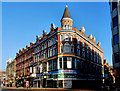
7
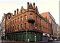
The "Deer's Head", Belfast (1)
A long-established bar at the corner of Lower Garfield Street Image (left) and (lower) North Street. The 1901 street directory shows it in existence under the ownership of “Robt Weir” – see also Image The area to the west (now Royal Avenue, then Hercules Place) was redeveloped in the late 19th century (explained in Image). Lower Garfield Street seems to be a product of that scheme. Its (approximate) predecessor was a forgotten thoroughfare known as “Round Entry”. Image shows part of the roof and chimney detail.
Image: © Albert Bridge
Taken: 18 Dec 2011
0.01 miles
8
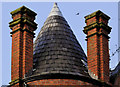
The "Deer's Head", Belfast (2)
See Image Detail at roof level. The chimneys might be real or they might be architectural embellishment.
Image: © Albert Bridge
Taken: 18 Dec 2011
0.01 miles
9
Decorated columns, Belfast (2)
Image: © Albert Bridge
Taken: 19 Apr 2009
0.01 miles
10
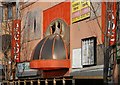
The North Street Arcade, Belfast
See Image The North Street Arcade (running from North Street to Donegall Street) was built in 1936 on the site of a linen warehouse. It was seriously damaged by fire in April 2004. It remains in its fire-damaged state. Its loss has generated some emotion but there are no signs of restoration. This is the North Street end.
Image: © Albert Bridge
Taken: 17 Feb 2008
0.01 miles