IMAGES TAKEN NEAR TO
Trossachs Park, BELFAST, BT10 0AX
Introduction
This page details the photographs taken nearby to Trossachs Park, BT10 0AX by members of the Geograph project.
The Geograph project started in 2005 with the aim of publishing, organising and preserving representative images for every square kilometre of Great Britain, Ireland and the Isle of Man.

There are currently over 7.5m images from over14,400 individuals and you can help contribute to the project by visiting https://www.geograph.org.uk
Image Map
Images are licensed for reuse under creativecommons.org/licenses/by-sa/2.0
Notes
- Clicking on the map will re-center to the selected point.
- The higher the marker number, the further away the image location is from the centre of the postcode.
Image Listing (6 Images Found)
Images are licensed for reuse under creativecommons.org/licenses/by-sa/2.0
Image
Details
Distance
1
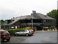
The Clubhouse
The new Dunmurry Golf Course and Clubhouse were opened on St Patrick's Day 1983.
Image: © Brian Shaw
Taken: 23 Sep 2005
0.15 miles
2
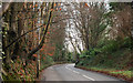
Dunmurry Lane, Dunmurry
Dunmurry Lane runs from Dunmurry crossroads Image to the Upper Malone Road Image The view is towards the latter as it passes Dunmurry Golf Club.
Image: © Albert Bridge
Taken: 22 Jan 2010
0.22 miles
3
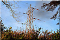
Pylon and power lines, Dunmurry
If my map reading is correct, this one is not connected to Image Instead the line seems to start near Black’s Road, passing over Dunmurry golf course to here where it crosses Dunmurry Lane before continuing to Image
Image: © Albert Bridge
Taken: 21 Nov 2010
0.22 miles
4
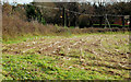
Maize field, Dunmurry (2)
See Image Part of the same field with the maize now cut.
Image: © Albert Bridge
Taken: 21 Nov 2010
0.24 miles
5
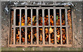
Grating and leaves, Dunmurry
A grating, along this part of Dunmurry Lane Image, blocked by autumn leaves.
Image: © Albert Bridge
Taken: 18 Oct 2010
0.24 miles
6
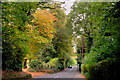
Dunmurry Lane, Dunmurry (3)
The view to Dunmurry as the road passes the golf course (both sides – behind the trees). The gap (lower left) allows access to a store.
Image: © Albert Bridge
Taken: 18 Oct 2010
0.25 miles