IMAGES TAKEN NEAR TO
Pinewood Close, BRISTOL, BS9 4AJ
Introduction
This page details the photographs taken nearby to Pinewood Close, BS9 4AJ by members of the Geograph project.
The Geograph project started in 2005 with the aim of publishing, organising and preserving representative images for every square kilometre of Great Britain, Ireland and the Isle of Man.

There are currently over 7.5m images from over14,400 individuals and you can help contribute to the project by visiting https://www.geograph.org.uk
Image Map
Images are licensed for reuse under creativecommons.org/licenses/by-sa/2.0
Notes
- Clicking on the map will re-center to the selected point.
- The higher the marker number, the further away the image location is from the centre of the postcode.
Image Listing (105 Images Found)
Images are licensed for reuse under creativecommons.org/licenses/by-sa/2.0
Image
Details
Distance
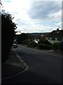
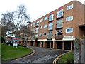
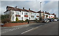
2
Eastern arm of Cote Lea Park, Westbury-on-Trym, Bristol
The sign on the left shows that numbers 24-45 Cote Lea Park are ahead.
Image: © Jaggery
Taken: 30 Jan 2013
0.04 miles
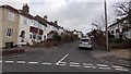
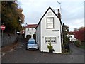
3
Westbury on Trym village
The river Trym flows beneath the picturesque stone bridge. The irregularly shaped cottage is known as the Dial House. This rural looking scene is set within the northern suburbs of Bristol.
Image: © C P Smith
Taken: 12 Aug 2010
0.06 miles
4

Cote Lea Park, Westbury-on-Trym, Bristol
Viewed from the corner of Pinewood Close.
Image: © Jaggery
Taken: 30 Jan 2013
0.07 miles
5
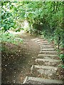
Footpath from Pinewood Close
This footpath leads to Westbury village from Pinewood Close. It's easier to go towards Westbury village rather than come back from it! The path passes what used to be the Westbury on Trym Wildlife Park.
Image: © C P Smith
Taken: 8 Sep 2010
0.07 miles
6
Westbury Court, Westbury-on-Trym
Block of flats viewed from Chock Lane.
Image: © Jaggery
Taken: 29 Oct 2012
0.08 miles
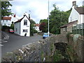
7
The Dial House, Westbury-on-Trym, Bristol
Viewed across Trym Road. The Dial House used to be a toll house. Channells Hill on the left was the road leading to the ferry across the Bristol Channel. The About Bristol website states that a woman who lived in the house was courted by one of the young men of the village, who had second thoughts and jilted her. She was devastated but decided to put on a brave front. She had the dial of a clock painted on the house, with the hands set at the time he left her, to humiliate him and remind the village of his ungentlemanly behaviour.
Image: © Jaggery
Taken: 29 Oct 2012
0.09 miles
8
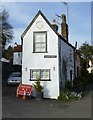
Dial House Tollhouse by Channell's Hill, Westbury on Trym
The Dial House, Channell's Hill, Westbury on Trym, BS9 3ET.
Surveyed
Milestone Society National ID: AV.BRI02
Image: © Alan Rosevear
Taken: 29 Mar 2014
0.09 miles
9
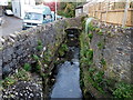
River Trym, Trym Road, Westbury-on-Trym, Bristol
Here looking like a stream, the River Trym flows along the south side of Trym Road.
Image: © Jaggery
Taken: 29 Oct 2012
0.09 miles
10
Eastfield Road houses east of Cote Lea Park, Westbury-on-Trym, Bristol
The Cote Lea Park junction is on the left.
Image: © Jaggery
Taken: 30 Jan 2013
0.10 miles