IMAGES TAKEN NEAR TO
Waters Lane, BRISTOL, BS9 4AA
Introduction
This page details the photographs taken nearby to Waters Lane, BS9 4AA by members of the Geograph project.
The Geograph project started in 2005 with the aim of publishing, organising and preserving representative images for every square kilometre of Great Britain, Ireland and the Isle of Man.

There are currently over 7.5m images from over14,400 individuals and you can help contribute to the project by visiting https://www.geograph.org.uk
Image Map
Images are licensed for reuse under creativecommons.org/licenses/by-sa/2.0
Notes
- Clicking on the map will re-center to the selected point.
- The higher the marker number, the further away the image location is from the centre of the postcode.
Image Listing (144 Images Found)
Images are licensed for reuse under creativecommons.org/licenses/by-sa/2.0
Image
Details
Distance
1
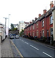
Waters Lane houses, Westbury-on-Trym
The 45 metre long row of houses is on the south side of Waters Lane.
Image: © Jaggery
Taken: 29 Oct 2012
0.02 miles
2
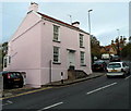
Pink house, Waters Lane, Westbury-on-Trym
Located about halfway up the ascent from Westbury Hill to Eastfield Road.
Image: © Jaggery
Taken: 29 Oct 2012
0.02 miles
3
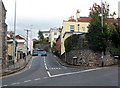
Waters Lane, Westbury on Trym, Bristol
Waters Lane climbs away from Westbury Hill (the B4055).
Image: © Jaggery
Taken: 29 Oct 2012
0.02 miles
4
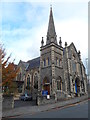
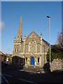
Side view of Westbury on Trym Methodist Church, Bristol
Located on the north side of the Waters Lane/Westbury Hill junction.
The church was built and opened in 1889 on the site
of a chapel built in 1811 and demolished early in 1889.
Image: © Jaggery
Taken: 29 Oct 2012
0.02 miles
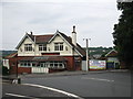
6
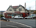
The Mouse, Westbury-on-Trym
The Waters Lane pub used to be known as The Royal Oak.
Image: © Jaggery
Taken: 29 Oct 2012
0.03 miles
7
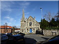
Westbury-on-Trym Methodist Church
Near the junction of Water's Lane and Westbury Hill.
Image: © Eirian Evans
Taken: 3 Feb 2016
0.03 miles
8
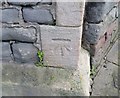
Ordnance Survey Cut Mark
This OS cut mark can be found on the SE angle of the Methodist Church. It marks a point 39.328m above mean sea level.
Image: © Adrian Dust
Taken: 17 Jan 2020
0.03 miles
9
Westbury-on-Trym Methodist Church
Originally built in 1889, it replaced an older chapel that had been used by the congregation.
Image: © Linda Bailey
Taken: 11 Jan 2006
0.03 miles
10
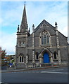
Front view of Westbury on Trym Methodist Church, Bristol
Located on the north side of the Waters Lane/Westbury Hill junction.
The church was built and opened in 1889 on the site
of a chapel built in 1811 and demolished early in 1889.
Image: © Jaggery
Taken: 29 Oct 2012
0.03 miles