IMAGES TAKEN NEAR TO
Church Road, BRISTOL, BS9 3EQ
Introduction
This page details the photographs taken nearby to Church Road, BS9 3EQ by members of the Geograph project.
The Geograph project started in 2005 with the aim of publishing, organising and preserving representative images for every square kilometre of Great Britain, Ireland and the Isle of Man.

There are currently over 7.5m images from over14,400 individuals and you can help contribute to the project by visiting https://www.geograph.org.uk
Image Map
Images are licensed for reuse under creativecommons.org/licenses/by-sa/2.0
Notes
- Clicking on the map will re-center to the selected point.
- The higher the marker number, the further away the image location is from the centre of the postcode.
Image Listing (146 Images Found)
Images are licensed for reuse under creativecommons.org/licenses/by-sa/2.0
Image
Details
Distance
1
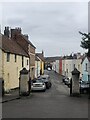
Church Road, Westbury-on-Trym
Seen from the churchyard of the Parish Church
Image: © Eirian Evans
Taken: 1 Sep 2021
0.01 miles
3
Elsie Briggs' House
An ancient house it is now a place of Christian prayer and reflection.
Image: © Neil Owen
Taken: 28 May 2019
0.02 miles
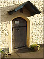
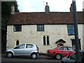
4
Elsie Briggs' House in the sun
Thought to have been built in around 1445, this was a large one-room 'hall house' that had no chimneys or intervening flooring. Over the years it had several alterations and additions but retains much of its original features and charm.
Dr. Elsie Briggs of Bristol University was a popular occupant from 1958 whilst uncovering the treasures of the house. Following her death in 1988, she bequeathed it to the church authorities for prayer.
Image: © Neil Owen
Taken: 28 May 2019
0.02 miles
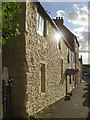
5
Fifteenth Century house, Church Road
This house at the top of Church Road dates from the 15th century and is presently used a religious study centre and house of prayer.
Image: © C P Smith
Taken: 12 Aug 2010
0.03 miles
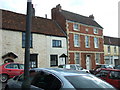
6
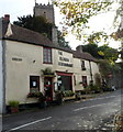
The Villager restaurant, Westbury-on-Trym, Bristol
The Villager in Church Road occupies two converted early 19th century cottages. The property has had various commercial uses. For example, in 1861 it was a bakery and a beerhouse named The Adelaide. C1900 a small extension was added to the property with a shop front and it became a grocery shop. Later a café, in 1973 it became The Gramophone Record selling a wide range of specialist classical records and sheet music.
In 1983, the original Villager was established. The business included a herb, spices and wholefood retail area and a tea room. In 1986, the business became a fully licensed restaurant, which it remains today.
Image: © Jaggery
Taken: 29 Oct 2012
0.03 miles
7
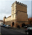
Westbury College remains, Westbury-on-Trym, Bristol
Viewed across College Road. A National Trust information plaque on the wall records that Westbury College was originally an imposing structure around a quadrangle, with towers, turrets and battlements. The college was built 1459-1469 as a residence for the dean and canons of Westbury Church by John Carpenter, bishop of Worcester and Westbury.
In 1544 on the dissolution of religious houses, it was converted to a private dwelling. In 1643 it was set of fire by Prince Rupert to prevent its occupation by the Parliamentary forces. Only the gatehouse, two round towers and the boundary walls of the River Trym now remain.
By 1771 the Georgian house was built on part of the site. The whole property was purchased by subscription in 1894 and vested in The National Trust in 1907.
Image: © Jaggery
Taken: 29 Oct 2012
0.03 miles
8
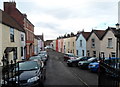
Church Road viewed from the church gates, Westbury-on-Trym
Look west from the edge of Holy Trinity parish church. http://www.geograph.org.uk/photo/3721833
Image: © Jaggery
Taken: 29 Oct 2012
0.03 miles
9
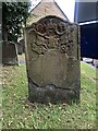
Gravestone at Westbury-on-Trym Churchyard
This elaborate gravestone is in memory of two children who died aged 8 and 2 years
Image: © Eirian Evans
Taken: 1 Sep 2021
0.03 miles
10
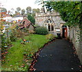
Parish office, Holy Trinity, Westbury-on-Trym
Located in the NW corner of the churchyard.
Image: © Jaggery
Taken: 29 Oct 2012
0.04 miles