IMAGES TAKEN NEAR TO
Haig Close, BRISTOL, BS9 2PT
Introduction
This page details the photographs taken nearby to Haig Close, BS9 2PT by members of the Geograph project.
The Geograph project started in 2005 with the aim of publishing, organising and preserving representative images for every square kilometre of Great Britain, Ireland and the Isle of Man.

There are currently over 7.5m images from over14,400 individuals and you can help contribute to the project by visiting https://www.geograph.org.uk
Image Map
Images are licensed for reuse under creativecommons.org/licenses/by-sa/2.0
Notes
- Clicking on the map will re-center to the selected point.
- The higher the marker number, the further away the image location is from the centre of the postcode.
Image Listing (49 Images Found)
Images are licensed for reuse under creativecommons.org/licenses/by-sa/2.0
Image
Details
Distance
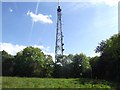
2
Henbury : Mast
A television mast on top of Kings Weston Hill.
Image: © Lewis Clarke
Taken: 8 Sep 2020
0.12 miles
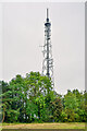
4
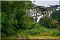
Kings Weston Hill and Transmitter
Looking along the path, which runs along the ridge of Kings Weston Hill, towards the transmitter. The ridge is grassland, with the sides of the ridge covered by woodland on both sides.
Image: © Linda Bailey
Taken: 29 May 2006
0.12 miles
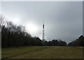
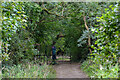
5
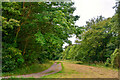
Shirehampton : Footpath
A footpath heads through the fields on top of Kings Weston Hill.
Image: © Lewis Clarke
Taken: 8 Sep 2020
0.13 miles
6
Shirehampton : Grassy Field
A right of way heads through the field.
Image: © Lewis Clarke
Taken: 8 Sep 2020
0.13 miles
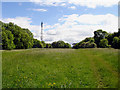
7
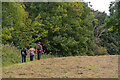
Shirehampton : Grassy Field
Some people head across Kings Weston Hill.
Image: © Lewis Clarke
Taken: 8 Sep 2020
0.14 miles
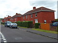
8
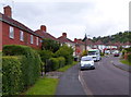
Elberton Road, Bristol
Viewed from the High Grove end looking towards Westbury Lane.
Image: © Jaggery
Taken: 23 Jun 2012
0.16 miles
9
High Grove houses, Bristol
Viewed from the corner of Elberton Road, opposite Highgrove Church. http://www.geograph.org.uk/photo/3274072
Image: © Jaggery
Taken: 23 Jun 2012
0.16 miles
10
Shirehampton : Footpath
A footpath heads off Kings Weston Hill.
Image: © Lewis Clarke
Taken: 8 Sep 2020
0.17 miles