IMAGES TAKEN NEAR TO
The Dingle, BRISTOL, BS9 2PA
Introduction
This page details the photographs taken nearby to The Dingle, BS9 2PA by members of the Geograph project.
The Geograph project started in 2005 with the aim of publishing, organising and preserving representative images for every square kilometre of Great Britain, Ireland and the Isle of Man.

There are currently over 7.5m images from over14,400 individuals and you can help contribute to the project by visiting https://www.geograph.org.uk
Image Map
Images are licensed for reuse under creativecommons.org/licenses/by-sa/2.0
Notes
- Clicking on the map will re-center to the selected point.
- The higher the marker number, the further away the image location is from the centre of the postcode.
Image Listing (50 Images Found)
Images are licensed for reuse under creativecommons.org/licenses/by-sa/2.0
Image
Details
Distance
1
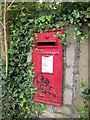
Postbox, Coombe Dingle
George V postbox BS9 278 is on The Dingle opposite the junction with Grove Road.
Image: © Derek Harper
Taken: 28 Sep 2014
0.04 miles
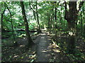
2
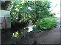
Path under Dingle Road (A4162)
Alongside the River Trym
Image: © Eirian Evans
Taken: 19 Sep 2017
0.05 miles
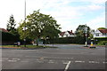
4
Bus stop and shelter, A4162, south of Coombe Dingle
Image: © David Smith
Taken: 29 Dec 2015
0.06 miles
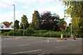
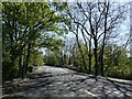
7
Crossroads on Sylvan Way, Coombe Dingle
This is the spot where the road changes to Sylvan Way on the left from Dingle Road on the right.
Image: © David Howard
Taken: 1 Jun 2019
0.07 miles
8
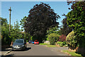
Grove Road
Looking in the other direction from Image] as the road widens. You still can't seen any houses, though. That's a fine copper beech.
Image: © Derek Harper
Taken: 18 Jul 2021
0.07 miles
9
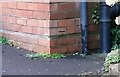
Ordnance Survey Cut Mark
This OS cut mark can be found on No1 Westbury Lane. It marks a point 23.238m above mean sea level.
Image: © Adrian Dust
Taken: 1 Nov 2021
0.08 miles
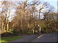
10
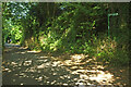
The Dingle
Footpath BCC 540/10 turns sharply back from the wooded lane to climb to Grove Road, which itself meets the lane a little further on beyond the walkers ahead.
Image: © Derek Harper
Taken: 18 Jul 2021
0.08 miles