IMAGES TAKEN NEAR TO
Sunny Hill, BRISTOL, BS9 2NH
Introduction
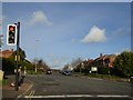
This page details the photographs taken nearby to Sunny Hill, BS9 2NH by members of the Geograph project.
The Geograph project started in 2005 with the aim of publishing, organising and preserving representative images for every square kilometre of Great Britain, Ireland and the Isle of Man.

There are currently over 7.5m images from over14,400 individuals and you can help contribute to the project by visiting https://www.geograph.org.uk
Image Map
Images are licensed for reuse under creativecommons.org/licenses/by-sa/2.0
Notes
- Clicking on the map will re-center to the selected point.
- The higher the marker number, the further away the image location is from the centre of the postcode.
Image Listing (27 Images Found)
Images are licensed for reuse under creativecommons.org/licenses/by-sa/2.0
Image
Details
Distance
1
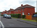
High Grove houses, Bristol
Viewed from the corner of Elberton Road, opposite Highgrove Church. http://www.geograph.org.uk/photo/3274072
Image: © Jaggery
Taken: 23 Jun 2012
0.07 miles
2
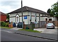
Highgrove Church, Bristol
Located in a street named High Grove, opposite the Elberton Road junction in the Sea Mills area of Bristol.
Image: © Jaggery
Taken: 23 Jun 2012
0.10 miles
3
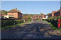
High Grove, Sea Mills
Seen from the junction with Shirehampton Road.
Image: © Stephen McKay
Taken: 10 Nov 2010
0.13 miles
4
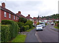
Elberton Road, Bristol
Viewed from the High Grove end looking towards Westbury Lane.
Image: © Jaggery
Taken: 23 Jun 2012
0.15 miles
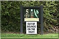
7
Community Forest Path in Shirehampton Park
The path runs along the edge of the park and the golf course; on the left is a narrow belt of trees bordering Shirehampton Road.
Image: © Derek Harper
Taken: 29 Mar 2014
0.18 miles
8

Giving us the eye
Garden cockerel, Shirehampton Park
Image: © Anthony O'Neil
Taken: 9 Apr 2021
0.18 miles
9
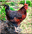
Cock of the Walk
This rooster shows who's boss in this garden at Shirehampton
Image: © Anthony O'Neil
Taken: 9 Apr 2021
0.18 miles
10
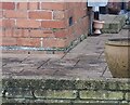
Ordnance Survey Cut Mark
This OS cut mark can be found on No47 Westbury Lane. It marks a point 38.100m above mean sea level.
Image: © Adrian Dust
Taken: 1 Nov 2021
0.20 miles