IMAGES TAKEN NEAR TO
Sylvan Way, BRISTOL, BS9 2LG
Introduction
This page details the photographs taken nearby to Sylvan Way, BS9 2LG by members of the Geograph project.
The Geograph project started in 2005 with the aim of publishing, organising and preserving representative images for every square kilometre of Great Britain, Ireland and the Isle of Man.

There are currently over 7.5m images from over14,400 individuals and you can help contribute to the project by visiting https://www.geograph.org.uk
Image Map
Images are licensed for reuse under creativecommons.org/licenses/by-sa/2.0
Notes
- Clicking on the map will re-center to the selected point.
- The higher the marker number, the further away the image location is from the centre of the postcode.
Image Listing (66 Images Found)
Images are licensed for reuse under creativecommons.org/licenses/by-sa/2.0
Image
Details
Distance
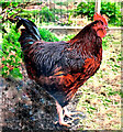
1

Giving us the eye
Garden cockerel, Shirehampton Park
Image: © Anthony O'Neil
Taken: 9 Apr 2021
0.05 miles
2
Cock of the Walk
This rooster shows who's boss in this garden at Shirehampton
Image: © Anthony O'Neil
Taken: 9 Apr 2021
0.05 miles
3
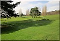
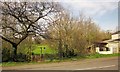
Shirehampton Park
Most of the park, which was donated to the National Trust in 1923, is a golf course. This is taken from the Community Forest Path, which edges up the eastern side of the park and course.
Image: © Derek Harper
Taken: 29 Mar 2014
0.05 miles
5
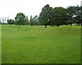
SE corner of Shirehampton Park Golf Course, Bristol
Viewed from the edge of Sylvan Way (the A4162). Shirehampton Park is a National Trust property.
Image: © Jaggery
Taken: 23 Jun 2012
0.06 miles
6
Shirehampton Park
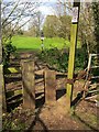
The Community Forest Path enters the park and its golf course here; a detail of Image The LDP keeps to the right-hand side of the park, while a public footpath, BCC/69/20, veers off to the left. A few metres ahead is a National Trust sign; the park was donated to the Trust in 1923. A history and description of the park, which formed part of the Kings Weston estate, is at https://historicengland.org.uk/listing/the-list/list-entry/1000335 .
Image: © Derek Harper
Taken: 29 Mar 2014
0.08 miles
7
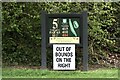
Two hazards on the Community Forest Path
First, walkers emerging from Three Acre Covert have to cross the busy A4162 Sylvan Way without the benefit of a pedestrian crossing, and then they have to make their way around Shirehampton Park golf course, with the line of the path poorly indicated and perilously close to at least one fairway. The fact that the park is National Trust land doesn't really help.
Image: © Derek Harper
Taken: 29 Mar 2014
0.08 miles
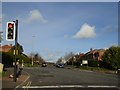
9
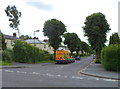
Woodleaze, Bristol
Viewed across Sylvan Way. The van is a Lux highway maintenance vehicle.
Image: © Jaggery
Taken: 23 Jun 2012
0.08 miles
10
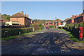
High Grove, Sea Mills
Seen from the junction with Shirehampton Road.
Image: © Stephen McKay
Taken: 10 Nov 2010
0.09 miles