IMAGES TAKEN NEAR TO
Bell Barn Road, BRISTOL, BS9 2DA
Introduction
This page details the photographs taken nearby to Bell Barn Road, BS9 2DA by members of the Geograph project.
The Geograph project started in 2005 with the aim of publishing, organising and preserving representative images for every square kilometre of Great Britain, Ireland and the Isle of Man.

There are currently over 7.5m images from over14,400 individuals and you can help contribute to the project by visiting https://www.geograph.org.uk
Image Map
Images are licensed for reuse under creativecommons.org/licenses/by-sa/2.0
Notes
- Clicking on the map will re-center to the selected point.
- The higher the marker number, the further away the image location is from the centre of the postcode.
Image Listing (60 Images Found)
Images are licensed for reuse under creativecommons.org/licenses/by-sa/2.0
Image
Details
Distance
1
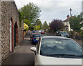
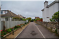
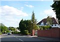
A suburban road
This is a view north west along Coombe Lane. There is a benchmark Image on the brickwork beyond the red-painted door on the left.
Image: © Neville Goodman
Taken: 17 May 2020
0.07 miles
2
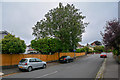
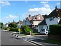
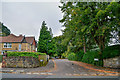
Henbury : Coombe Lane
Looking along Coombe Lane.
Image: © Lewis Clarke
Taken: 8 Sep 2020
0.07 miles
4
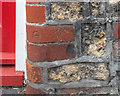
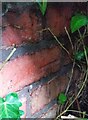
An odd benchmark
This apparent benchmark in Coombe Lane Image is in the correct position according to the OS database (NE FACE NO79 COOMBE LANE), but it doesn't look quite right. I wonder if this was a mark made by the occupant of the house when restorative work obliterated the original.
Image: © Neville Goodman
Taken: 17 May 2020
0.09 miles
5
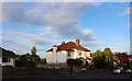
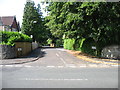
Henbury : Coombe Lane
A little road off Coombe Lane.
Image: © Lewis Clarke
Taken: 8 Sep 2020
0.09 miles
6
Woodland Grove
Woodland Grove is a quiet "L" shaped residential street between Bell Barn Rd and Coombe lane on the western fringes of Westbury on Trym
Image: © Nigel Mykura
Taken: 12 Jun 2010
0.10 miles
7
Ordnance Survey Cut Mark
This OS cut mark can be found on the wall north side of Dingle Road. It marks a point 26.630m above mean sea level.
Image: © Adrian Dust
Taken: 1 Nov 2021
0.11 miles
8
West Coombe
A short residential cul-de-sac seen from Coombe Lane.
Image: © David Purchase
Taken: 18 Jul 2018
0.11 miles
9
Coombe lane
Looking south down Coombe lane from the northern end at the junction with Dingle Rd between Coombe Dingle and Westbury on Trym
Image: © Nigel Mykura
Taken: 12 Jun 2010
0.11 miles
10
Henbury : West Coombe
Looking along West Coombe off Coombe Lane.
Image: © Lewis Clarke
Taken: 8 Sep 2020
0.12 miles