IMAGES TAKEN NEAR TO
Stoke Hill, BRISTOL, BS9 1JE
Introduction
This page details the photographs taken nearby to Stoke Hill, BS9 1JE by members of the Geograph project.
The Geograph project started in 2005 with the aim of publishing, organising and preserving representative images for every square kilometre of Great Britain, Ireland and the Isle of Man.

There are currently over 7.5m images from over14,400 individuals and you can help contribute to the project by visiting https://www.geograph.org.uk
Image Map
Images are licensed for reuse under creativecommons.org/licenses/by-sa/2.0
Notes
- Clicking on the map will re-center to the selected point.
- The higher the marker number, the further away the image location is from the centre of the postcode.
Image Listing (106 Images Found)
Images are licensed for reuse under creativecommons.org/licenses/by-sa/2.0
Image
Details
Distance
1
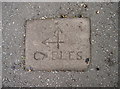
Set in the pavement
A curious marker stone, set in the pavement of Stoke Hill, offers little information. Presumably it is a boundary stone, or possibly based on ecclesiastical wards. See Image] for a wider view.
Image: © Neil Owen
Taken: 7 Sep 2017
0.02 miles
2
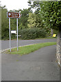
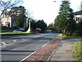
This way to the Uni gardens
The junction of Stoke Hill and Stoke Park Road, with a handy pointer to the gardens. Also in shot in the pavement is a curious marker - see Image
Image: © Neil Owen
Taken: 7 Sep 2017
0.02 miles
3
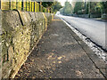
Street leading to Bristol Downs
Looking along Stoke Hill towards The Downs, there is an OS benchmark Image low down on the wall on the left.
Image: © Neville Goodman
Taken: 10 Jan 2021
0.02 miles
4
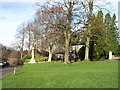
At the top of Stoke Hill, Bristol
The Stoke Bishop War Memorial is well seen here. Beyond and on its left is one of the Halls of Residence of the University of Bristol.
Image: © David Purchase
Taken: 25 Dec 2013
0.02 miles
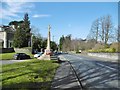
5
Stoke Hill, Bristol
Looking down towards Stoke Bishop from the Durdham Downs. The Stoke Bishop War Memorial is clearly seen.
Taken at 12:00:00 according to the GPS (a much more accurate clock than that on the camera!).
Image: © David Purchase
Taken: 25 Dec 2013
0.02 miles
6
Stoke Bishop, war memorial
On Stoke Hill, commemorating the hundred local men fallen in WWI.
Image: © Mike Faherty
Taken: 7 Mar 2015
0.02 miles

8
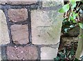
Ordnance Survey Cut Mark
This OS cut mark can be found on the wall of Springfort Lodge, Stoke Hill. It marks a point 88.800m above mean sea level.
Image: © Adrian Dust
Taken: 17 Jan 2020
0.03 miles
9
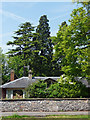
Trees, Stoke Park Road, Bristol
A pleasant group of conifers in varying shades of green.
Image: © Stephen Richards
Taken: 23 May 2012
0.05 miles
10
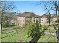
Stoke Bishop, Churchill Hall
Part of a large complex of halls of residence, on Stoke Park Road. http://www.bristol.ac.uk/churchill-hall/
Image: © Mike Faherty
Taken: 7 Mar 2015
0.05 miles