IMAGES TAKEN NEAR TO
Rownham Mead, BRISTOL, BS8 4YF
Introduction
This page details the photographs taken nearby to Rownham Mead, BS8 4YF by members of the Geograph project.
The Geograph project started in 2005 with the aim of publishing, organising and preserving representative images for every square kilometre of Great Britain, Ireland and the Isle of Man.

There are currently over 7.5m images from over14,400 individuals and you can help contribute to the project by visiting https://www.geograph.org.uk
Image Map
Images are licensed for reuse under creativecommons.org/licenses/by-sa/2.0
Notes
- Clicking on the map will re-center to the selected point.
- The higher the marker number, the further away the image location is from the centre of the postcode.
Image Listing (1200 Images Found)
Images are licensed for reuse under creativecommons.org/licenses/by-sa/2.0
Image
Details
Distance
1
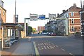
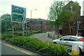
Multiple Choice
Routes out of Bristol via Merchants Road
Image: © Anthony O'Neil
Taken: 23 May 2017
0.01 miles
2
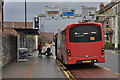
Bristol : Merchants Road
Merchants Road with a bus stopped letting on a passenger.
Image: © Lewis Clarke
Taken: 24 Mar 2015
0.01 miles
3
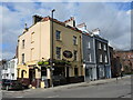
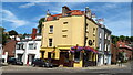
The Merchant's Arms on Merchant's Road
A corner boozer near the old docks (indeed, close to the old Merchant's Dock of old). Along this row used to be an infants' school which later became the Trinity Rooms before being demolished.
Image: © Neil Owen
Taken: 4 Mar 2022
0.02 miles
4
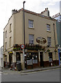
The Merchant's Arms
Appropriately situated in Merchant's Road. It should also be noted that the road is a modern version that was altered from the original route in the 1960s.
Image: © Neil Owen
Taken: 10 Apr 2015
0.02 miles
5
Bristol - Merchants Arms, Cumberland Basin
Image: © Colin Park
Taken: 10 Jul 2022
0.02 miles
6
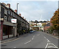
Merchants Road, Hotwells, Bristol
Looking north from the corner of Cumberland Basin Road along the A4 Merchants Road.
Image: © Jaggery
Taken: 21 Oct 2012
0.02 miles
7
The road to the ferry
Bristol's old city docks are no longer a place of industry and trade. Instead, the little ferry boats travel around the Floating Harbour delivering businessmen and tourists from one side to the other, hence avoiding lots of walking. The local surrounds are marked to draw them in.
Image: © Neil Owen
Taken: 10 Apr 2015
0.03 miles
8
Bristol : Hotwell Road A4
Hotwell Road and the Holy Trinity in view.
Image: © Lewis Clarke
Taken: 24 Mar 2015
0.03 miles
9
Into Merchants Road, Hotwells
A busy intersection to the west of Bristol city centre.
Image: © Jonathan Billinger
Taken: 2 May 2015
0.03 miles
10
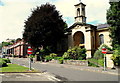
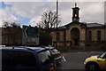
Hotwell Road - BS8
Holy Trinity Church and Hillsborough Flats are large buildings on this stretch of in Hotwell Road. The Grade II* listed church was built in 1829 but the interior had to be completely rebuilt after being gutted during the WWII blitz. Hillsborough Flats seem to have been constructed in 1940-50s. This is a view in the direction of the Dowry Square with Bristol city centre behind the photographer.
Image: © David Hallam-Jones
Taken: 2 Aug 2012
0.04 miles